Woodside East geodata
Woodside East (Delaware) is a populated place; located in United States in America/New_York (GMT-4) time zone. With population of 2,316 people, there are 11049 cities with bigger population in this country. Compared to other cities in United States, 54.2% of cities are located further ↑North; 85.5% of cities are located further ←West and 90% of cities have higher elevation than Woodside East. Note1


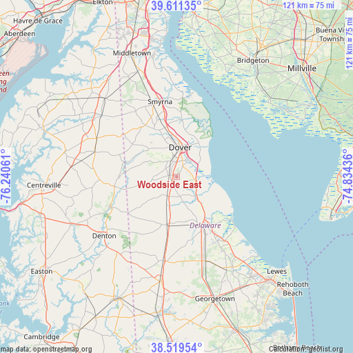
Woodside East GPS coordinates[2]
39° 4' 3.216" North, 75° 32' 14.928" West
| Map corner | latitude | longitude |
|---|---|---|
| Upper-left | 39.61135°, | -76.24061° |
| Center: | 39.06756°, | -75.53748° |
| Lower-right: | 38.51954°, | -74.83436° |
| Map W x H: | 121.4×121.4 km | = 75.4×75.4mi |
| max Lat: | 71.29058° ⇑54.2% North |
| Woodside East: | 39.06756° |
| min Lat: | ⇓45.8% South 19.06759° |
| min Long | Woodside East | max Long |
| -171.73463° | -75.53748° | -66.98998° |
| W 85.5%⇐ | ⇒14.5% E |
Elevation
Elevation of Woodside East is 16 m = 52 ft, and this is 278.8 m = 915 ft below average elevation for this country.
| Max E: |
3189 m = 10463 ft | 90% |
| Avg. | 294.8 m = 967 ft | |
| Woodside East | 16 m = 52 ft | |
Min E: |
-60 m = -197 ft | 10% |
See also: United States elevation on elevation.city.
Geographical zone
Woodside East is located in North temperate zone (between Tropic of Cancer and the Arctic Circle). Distance of this Northern Tropic circle is 1738 km =1079.9 mi to South.| Distance of | km | miles | from Woodside East |
|---|---|---|---|
| North Pole | 5663.2 | 3518.9 | to North |
| Arctic Circle | 3057.3 | 1899.7 | to North |
| Tropic Cancer | 1738 | 1079.9 | to South |
| Equator | 4343.9 | 2699.2 | to South |


Nearby cities:
15 places around Woodside East: (largest is in red/bold)
• Camden
5.1 km =3.2 mi,  355°
355°
• Cheswold
17.4 km =10.8 mi,  346°
346°
• Dover
10.1 km =6.3 mi,  6°
6°
• Dover Base Housing
7.2 km =4.5 mi,  39°
39°
• Felton
7.4 km =4.6 mi,  208°
208°
• Frederica
9 km =5.6 mi,  136°
136°
• Greensboro
25.4 km =15.8 mi,  245°
245°
• Harrington
16.4 km =10.2 mi,  192°
192°
• Highland Acres
6.1 km =3.8 mi, 12°
• Kent Acres
7.2 km =4.5 mi, 8°
• Milford
19.7 km =12.2 mi,  151°
151°
• Rising Sun-Lebanon
4.6 km =2.9 mi, 38°
• Riverview
5.1 km =3.2 mi, 153°
• Rodney Village
7.2 km =4.5 mi,  3°
3°
• Wyoming
5.9 km =3.7 mi,  341°
341°
Sources, notices
• [Note1] Compared only with cities in United States existing in our database
• [Src1] Map data: © OpenStreetMap contributors (CC-BY-SA)
• [Src2] Other city data from geonames.org with taken over terms of usage.
• [Src3] Geographical zone / Annual Mean Temperature by Robert A. Rohde @ Wikipedia
