Village Green-Green Ridge geodata
Village Green-Green Ridge (Pennsylvania) is a populated place; located in United States in America/New_York (GMT-4) time zone. With population of 7,822 people, there are 5371 cities with bigger population in this country. Compared to other cities in United States, 52.1% of cities are located further ↓South; 85.9% of cities are located further ←West and 78.8% of cities have higher elevation than Village Green-Green Ridge. Note1
Administrative division(s):
- Level 1: Pennsylvania
- Level 2: Delaware County
- Level 3: Township of Aston
Current local time in Village Green-Green Ridge:
05:00 AM, FridayDifference from your time zone: hours


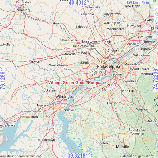
Village Green-Green Ridge GPS coordinates[2]
39° 51' 49.068" North, 75° 25' 31.728" West
| Map corner | latitude | longitude |
|---|---|---|
| Upper-left | 40.4012°, | -76.12861° |
| Center: | 39.86363°, | -75.42548° |
| Lower-right: | 39.32181°, | -74.72236° |
| Map W x H: | 120×120 km | = 74.6×74.6mi |
| max Lat: | 71.29058° ⇑47.9% North |
| Village Green-Green Ridge: | 39.86363° |
| min Lat: | ⇓52.1% South 19.06759° |
| min Long | Village Green-G | max Long |
| -171.73463° | -75.42548° | -66.98998° |
| W 85.9%⇐ | ⇒14.1% E |
Elevation
Elevation of Village Green-Green Ridge is 52 m = 171 ft, and this is 242.8 m = 797 ft below average elevation for this country.
| Max E: |
3189 m = 10463 ft | 78.8% |
| Avg. | 294.8 m = 967 ft | |
| Village Green-Green Ridge | 52 m = 171 ft | |
Min E: |
-60 m = -197 ft | 21.2% |
See also: United States elevation on elevation.city.
Geographical zone
Village Green-Green Ridge is located in North temperate zone (between Tropic of Cancer and the Arctic Circle). Distance of this Northern Tropic circle is 1826.5 km =1134.9 mi to South.| Distance of | km | miles | from Village Green-Green Ridge |
|---|---|---|---|
| North Pole | 5574.6 | 3463.9 | to North |
| Arctic Circle | 2968.8 | 1844.7 | to North |
| Tropic Cancer | 1826.5 | 1134.9 | to South |
| Equator | 4432.4 | 2754.2 | to South |


Nearby cities:
15 places around Village Green-Green Ridge: (largest is in red/bold)
• Boothwyn
4 km =2.5 mi,  200°
200°
• Brookhaven
3.7 km =2.3 mi,  80°
80°
• Chester
6 km =3.7 mi,  104°
104°
• Chester Heights
5.2 km =3.2 mi,  304°
304°
• Claymont
7.6 km =4.7 mi, 202°
• Eddystone
6.9 km =4.3 mi,  93°
93°
• Lima
6.1 km =3.8 mi,  347°
347°
• Linwood
4.1 km =2.5 mi,  179°
179°
• Marcus Hook
5 km =3.1 mi,  173°
173°
• Media
6.7 km =4.2 mi,  28°
28°
• Parkside
4 km =2.5 mi, 88°
• Rose Valley
5 km =3.1 mi,  43°
43°
• Trainer
4.1 km =2.5 mi, 166°
• Upland
3.9 km =2.4 mi,  108°
108°
• Woodlyn
7.6 km =4.7 mi, 82°
Sources, notices
• [Note1] Compared only with cities in United States existing in our database
• [Src1] Map data: © OpenStreetMap contributors (CC-BY-SA)
• [Src2] Other city data from geonames.org with taken over terms of usage.
• [Src3] Geographical zone / Annual Mean Temperature by Robert A. Rohde @ Wikipedia
