Wickerham Manor-Fisher geodata
Wickerham Manor-Fisher (Pennsylvania) is a populated place; located in United States in America/New_York (GMT-4) time zone. With population of 1,728 people, there are 12817 cities with bigger population in this country. Compared to other cities in United States, 55.3% of cities are located further ↓South; 73.7% of cities are located further ←West and 79.3% of cities have lower elevation than Wickerham Manor-Fisher. Note1
Administrative division(s):
- Level 1: Pennsylvania
- Level 2: Washington County
- Level 3: Township of Carroll
Current local time in Wickerham Manor-Fisher:
04:17 AM, TuesdayDifference from your time zone: hours


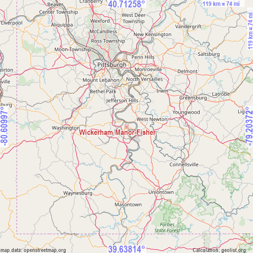
Wickerham Manor-Fisher GPS coordinates[2]
40° 10' 38.964" North, 79° 54' 24.624" West
| Map corner | latitude | longitude |
|---|---|---|
| Upper-left | 40.71258°, | -80.60997° |
| Center: | 40.17749°, | -79.90684° |
| Lower-right: | 39.63814°, | -79.20372° |
| Map W x H: | 119.5×119.5 km | = 74.3×74.3mi |
| max Lat: | 71.29058° ⇑44.7% North |
| Wickerham Manor-Fisher: | 40.17749° |
| min Lat: | ⇓55.3% South 19.06759° |
| min Long | Wickerham Manor | max Long |
| -171.73463° | -79.90684° | -66.98998° |
| W 73.7%⇐ | ⇒26.3% E |
Elevation
Elevation of Wickerham Manor-Fisher is 347 m = 1138 ft, and this is 52.2 m = 171 ft above average elevation for this country.
| Max E: |
3189 m = 10463 ft | 20.7% |
| Wickerham Manor-Fisher | 347 m 1138 ft | |
| Avg. | 294.8 m = 967 ft | |
Min E: |
-60 m = -197 ft | 79.3% |
See also: United States elevation on elevation.city.
Geographical zone
Wickerham Manor-Fisher is located in North temperate zone (between Tropic of Cancer and the Arctic Circle). Distance of this Northern Tropic circle is 1861.4 km =1156.6 mi to South.| Distance of | km | miles | from Wickerham Manor-Fisher |
|---|---|---|---|
| North Pole | 5539.7 | 3442.2 | to North |
| Arctic Circle | 2933.9 | 1823 | to North |
| Tropic Cancer | 1861.4 | 1156.6 | to South |
| Equator | 4467.3 | 2775.9 | to South |


Nearby cities:
15 places around Wickerham Manor-Fisher: (largest is in red/bold)
• Allenport
10.1 km =6.3 mi,  150°
150°
• Baidland
5.8 km =3.6 mi,  289°
289°
• Belle Vernon
6.8 km =4.2 mi, 149°
• Charleroi
4.5 km =2.8 mi,  170°
170°
• Donora
4.2 km =2.6 mi,  96°
96°
• Elizabeth
10.3 km =6.4 mi,  8°
8°
• Fairhope
9.1 km =5.7 mi,  141°
141°
• Fellsburg
7 km =4.3 mi,  84°
84°
• Lynnwood-Pricedale
7 km =4.3 mi, 137°
• Monessen
3.6 km =2.2 mi, 153°
• Monongahela
3.3 km =2.1 mi,  330°
330°
• New Eagle
4.8 km =3 mi,  314°
314°
• North Belle Vernon
6.3 km =3.9 mi, 148°
• North Charleroi
2.9 km =1.8 mi,  181°
181°
• Speers
6.3 km =3.9 mi,  158°
158°
Sources, notices
• [Note1] Compared only with cities in United States existing in our database
• [Src1] Map data: © OpenStreetMap contributors (CC-BY-SA)
• [Src2] Other city data from geonames.org with taken over terms of usage.
• [Src3] Geographical zone / Annual Mean Temperature by Robert A. Rohde @ Wikipedia
