Manderson-White Horse Creek geodata
Manderson-White Horse Creek (South Dakota) is a populated place; located in United States in America/Denver (GMT-6) time zone. With population of 626 people, there are 19406 cities with bigger population in this country. Compared to other cities in United States, 85% of cities are located further ↓South; 82.1% of cities are located further →East and 93.4% of cities have lower elevation than Manderson-White Horse Creek. Note1
Administrative division(s):
- Level 1: South Dakota
- Level 2: Oglala Lakota County
- Level 3: Unorganized Territory of West Oglala Lakota
Current local time in Manderson-White Horse Creek:
04:31 AM, FridayDifference from your time zone: hours


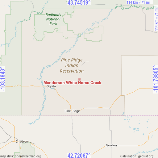
Manderson-White Horse Creek GPS coordinates[2]
43° 14' 6.288" North, 102° 29' 28.212" West
| Map corner | latitude | longitude |
|---|---|---|
| Upper-left | 43.74519°, | -103.1943° |
| Center: | 43.23508°, | -102.49117° |
| Lower-right: | 42.72067°, | -101.78805° |
| Map W x H: | 113.9×113.9 km | = 70.8×70.8mi |
| max Lat: | 71.29058° ⇑15% North |
| Manderson-White Horse Creek: | 43.23508° |
| min Lat: | ⇓85% South 19.06759° |
| min Long | Manderson-White | max Long |
| -171.73463° | -102.49117° | -66.98998° |
| W 17.9%⇐ | ⇒82.1% E |
Elevation
Elevation of Manderson-White Horse Creek is 992 m = 3255 ft, and this is 697.2 m = 2287 ft above average elevation for this country.
| Max E: |
3189 m = 10463 ft | 6.6% |
| Manderson-White Horse Creek | 992 m 3255 ft | |
| Avg. | 294.8 m = 967 ft | |
Min E: |
-60 m = -197 ft | 93.4% |
See also: United States elevation on elevation.city.
Geographical zone
Manderson-White Horse Creek is located in North temperate zone (between Tropic of Cancer and the Arctic Circle). Distance of this Northern Tropic circle is 2201.4 km =1367.9 mi to South.| Distance of | km | miles | from Manderson-White Horse Creek |
|---|---|---|---|
| North Pole | 5199.8 | 3231 | to North |
| Arctic Circle | 2593.9 | 1611.8 | to North |
| Tropic Cancer | 2201.4 | 1367.9 | to South |
| Equator | 4807.3 | 2987.1 | to South |


Nearby cities:
15 places around Manderson-White Horse Creek: (largest is in red/bold)
• Chadron
61.2 km =38 mi,  222°
222°
• Crawford
96.9 km =60.2 mi,  230°
230°
• Gordon
53.3 km =33.1 mi,  153°
153°
• Green Valley
102 km =63.4 mi,  330°
330°
• Hay Springs
63.4 km =39.4 mi,  194°
194°
• Hot Springs
82.5 km =51.3 mi,  285°
285°
• Kyle
33.1 km =20.6 mi,  50°
50°
• Martin
61.9 km =38.5 mi,  96°
96°
• New Underwood
99.4 km =61.8 mi,  343°
343°
• Oglala
20.8 km =12.9 mi,  255°
255°
• Pine Ridge
23.9 km =14.9 mi, 192°
• Porcupine
13 km =8.1 mi,  87°
87°
• Rushville
57.5 km =35.7 mi,  177°
177°
• Wall
86.6 km =53.8 mi,  13°
13°
• Wanblee
76.7 km =47.7 mi,  61°
61°
Sources, notices
• [Note1] Compared only with cities in United States existing in our database
• [Src1] Map data: © OpenStreetMap contributors (CC-BY-SA)
• [Src2] Other city data from geonames.org with taken over terms of usage.
• [Src3] Geographical zone / Annual Mean Temperature by Robert A. Rohde @ Wikipedia
