Manitou Beach-Devils Lake geodata
Manitou Beach-Devils Lake (Michigan) is a populated place; located in United States in America/Detroit (GMT-4) time zone. With population of 2,019 people, there are 11893 cities with bigger population in this country. Compared to other cities in United States, 75.5% of cities are located further ↓South; 58.4% of cities are located further ←West and 75.4% of cities have lower elevation than Manitou Beach-Devils Lake. Note1
Current local time in Manitou Beach-Devils Lake:
05:01 AM, FridayDifference from your time zone: hours


Manitou Beach-Devils Lake GPS coordinates[2]
41° 58' 32.34" North, 84° 17' 10.176" West
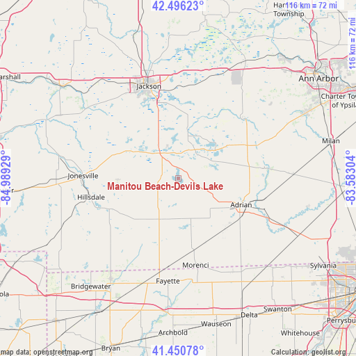
| Map corner | latitude | longitude |
|---|---|---|
| Upper-left | 42.49623°, | -84.98929° |
| Center: | 41.97565°, | -84.28616° |
| Lower-right: | 41.45078°, | -83.58304° |
| Map W x H: | 116.2×116.2 km | = 72.2×72.2mi |
| max Lat: | 71.29058° ⇑24.5% North |
| Manitou Beach-Devils Lake: | 41.97565° |
| min Lat: | ⇓75.5% South 19.06759° |
| min Long | Manitou Beach-D | max Long |
| -171.73463° | -84.28616° | -66.98998° |
| W 58.4%⇐ | ⇒41.6% E |
Elevation
Elevation of Manitou Beach-Devils Lake is 316 m = 1037 ft, and this is 21.2 m = 70 ft above average elevation for this country.
| Max E: |
3189 m = 10463 ft | 24.6% |
| Manitou Beach-Devils Lake | 316 m 1037 ft | |
| Avg. | 294.8 m = 967 ft | |
Min E: |
-60 m = -197 ft | 75.4% |
See also: United States elevation on elevation.city.
Geographical zone
Manitou Beach-Devils Lake is located in North temperate zone (between Tropic of Cancer and the Arctic Circle). Distance of this Northern Tropic circle is 2061.3 km =1280.8 mi to South.| Distance of | km | miles | from Manitou Beach-Devils Lake |
|---|---|---|---|
| North Pole | 5339.8 | 3318 | to North |
| Arctic Circle | 2733.9 | 1698.8 | to North |
| Tropic Cancer | 2061.3 | 1280.8 | to South |
| Equator | 4667.3 | 2900.1 | to South |


Nearby cities:
15 places around Manitou Beach-Devils Lake: (largest is in red/bold)
• Addison
5.2 km =3.2 mi,  283°
283°
• Adrian
22.4 km =13.9 mi,  112°
112°
• Brooklyn
14.8 km =9.2 mi,  12°
12°
• Clinton
28.1 km =17.5 mi,  67°
67°
• Hillsdale
29.1 km =18.1 mi,  257°
257°
• Hudson
14.5 km =9 mi,  202°
202°
• Jonesville
31.1 km =19.3 mi,  271°
271°
• Manchester
28.2 km =17.5 mi,  46°
46°
• Michigan Center
28.8 km =17.9 mi,  353°
353°
• Morenci
29 km =18 mi,  168°
168°
• Napoleon
20.8 km =12.9 mi, 9°
• Onsted
8.6 km =5.3 mi, 66°
• Tecumseh
28.4 km =17.6 mi,  83°
83°
• Vandercook Lake
25.7 km =16 mi,  340°
340°
• Waldron
29.7 km =18.5 mi, 201°
Sources, notices
• [Note1] Compared only with cities in United States existing in our database
• [Src1] Map data: © OpenStreetMap contributors (CC-BY-SA)
• [Src2] Other city data from geonames.org with taken over terms of usage.
• [Src3] Geographical zone / Annual Mean Temperature by Robert A. Rohde @ Wikipedia
