Montrose-Ghent geodata
Montrose-Ghent (Ohio) is a populated place; located in United States in America/New_York (GMT-4) time zone. With population of 5,177 people, there are 7025 cities with bigger population in this country. Compared to other cities in United States, 67.4% of cities are located further ↓South; 66.9% of cities are located further ←West and 75.5% of cities have lower elevation than Montrose-Ghent. Note1


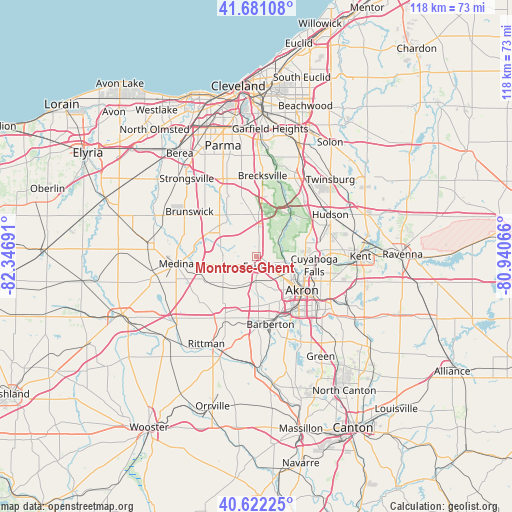
Montrose-Ghent GPS coordinates[2]
41° 9' 13.68" North, 81° 38' 37.608" West
| Map corner | latitude | longitude |
|---|---|---|
| Upper-left | 41.68108°, | -82.34691° |
| Center: | 41.1538°, | -81.64378° |
| Lower-right: | 40.62225°, | -80.94066° |
| Map W x H: | 117.7×117.7 km | = 73.1×73.1mi |
| max Lat: | 71.29058° ⇑32.6% North |
| Montrose-Ghent: | 41.1538° |
| min Lat: | ⇓67.4% South 19.06759° |
| min Long | Montrose-Ghent | max Long |
| -171.73463° | -81.64378° | -66.98998° |
| W 66.9%⇐ | ⇒33.1% E |
Elevation
Elevation of Montrose-Ghent is 317 m = 1040 ft, and this is 22.2 m = 73 ft above average elevation for this country.
| Max E: |
3189 m = 10463 ft | 24.5% |
| Montrose-Ghent | 317 m 1040 ft | |
| Avg. | 294.8 m = 967 ft | |
Min E: |
-60 m = -197 ft | 75.5% |
See also: United States elevation on elevation.city.
Geographical zone
Montrose-Ghent is located in North temperate zone (between Tropic of Cancer and the Arctic Circle). Distance of this Northern Tropic circle is 1970 km =1224.1 mi to South.| Distance of | km | miles | from Montrose-Ghent |
|---|---|---|---|
| North Pole | 5431.2 | 3374.8 | to North |
| Arctic Circle | 2825.3 | 1755.6 | to North |
| Tropic Cancer | 1970 | 1224.1 | to South |
| Equator | 4575.9 | 2843.3 | to South |


Nearby cities:
15 places around Montrose-Ghent: (largest is in red/bold)
• Akron
13.2 km =8.2 mi,  127°
127°
• Barberton
16 km =9.9 mi,  168°
168°
• Boston Heights
16.5 km =10.3 mi,  41°
41°
• Copley
6.1 km =3.8 mi,  180°
180°
• Cuyahoga Falls
13.5 km =8.4 mi,  99°
99°
• Fairlawn
4.1 km =2.5 mi,  135°
135°
• Munroe Falls
17.1 km =10.6 mi,  93°
93°
• Norton
13.9 km =8.6 mi, 178°
• Peninsula
12.4 km =7.7 mi, 38°
• Pigeon Creek
5.4 km =3.4 mi,  207°
207°
• Richfield
9.6 km =6 mi,  2°
2°
• Silver Lake
15.9 km =9.9 mi, 87°
• Stow
17 km =10.6 mi, 87°
• Tallmadge
17.9 km =11.1 mi,  108°
108°
• Wadsworth
16 km =9.9 mi, 206°
Sources, notices
• [Note1] Compared only with cities in United States existing in our database
• [Src1] Map data: © OpenStreetMap contributors (CC-BY-SA)
• [Src2] Other city data from geonames.org with taken over terms of usage.
• [Src3] Geographical zone / Annual Mean Temperature by Robert A. Rohde @ Wikipedia
