Homestead Base geodata
Homestead Base (Florida) is a section of populated place; located in United States in America/New_York (GMT-4) time zone. With population of 964 people, there are 16535 cities with bigger population in this country. Compared to other cities in United States, 99.3% of cities are located further ↑North; 71.2% of cities are located further ←West and 97.4% of cities have higher elevation than Homestead Base. Note1


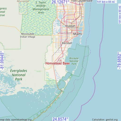
Homestead Base GPS coordinates[2]
25° 29' 37.428" North, 80° 23' 28.752" West
| Map corner | latitude | longitude |
|---|---|---|
| Upper-left | 26.12671°, | -81.09445° |
| Center: | 25.49373°, | -80.39132° |
| Lower-right: | 24.8574°, | -79.6882° |
| Map W x H: | 141.1×141.1 km | = 87.7×87.7mi |
| max Lat: | 71.29058° ⇑99.3% North |
| Homestead Base: | 25.49373° |
| min Lat: | ⇓0.7% South 19.06759° |
| min Long | Homestead Base | max Long |
| -171.73463° | -80.39132° | -66.98998° |
| W 71.2%⇐ | ⇒28.8% E |
Elevation
Elevation of Homestead Base is 6 m = 20 ft, and this is 288.8 m = 948 ft below average elevation for this country.
| Max E: |
3189 m = 10463 ft | 97.4% |
| Avg. | 294.8 m = 967 ft | |
| Homestead Base | 6 m = 20 ft | |
Min E: |
-60 m = -197 ft | 2.6% |
See also: United States elevation on elevation.city.
Geographical zone
Homestead Base is located in North temperate zone (between Tropic of Cancer and the Arctic Circle). Distance of this Northern Tropic circle is 228.7 km =142.1 mi to South.| Distance of | km | miles | from Homestead Base |
|---|---|---|---|
| North Pole | 7172.4 | 4456.7 | to North |
| Arctic Circle | 4566.5 | 2837.5 | to North |
| Tropic Cancer | 228.7 | 142.1 | to South |
| Equator | 2834.6 | 1761.3 | to South |


Nearby cities:
15 places around Homestead Base: (largest is in red/bold)
• Cutler Bay
10.8 km =6.7 mi,  29°
29°
• Cutler Ridge
10.7 km =6.6 mi,  24°
24°
• East Perrine
13.8 km =8.6 mi, 22°
• Florida City
10.2 km =6.3 mi,  239°
239°
• Goulds
7.7 km =4.8 mi,  6°
6°
• Homestead
9.1 km =5.7 mi,  252°
252°
• Lakes by the Bay
11 km =6.8 mi,  37°
37°
• Leisure City
3.8 km =2.4 mi,  272°
272°
• Naranja
4.2 km =2.6 mi,  310°
310°
• Palmetto Estates
14.5 km =9 mi, 11°
• Princeton
5.3 km =3.3 mi,  340°
340°
• Richmond Heights
15.5 km =9.6 mi, 8°
• Richmond West
13.5 km =8.4 mi, 343°
• South Miami Heights
11.6 km =7.2 mi, 5°
• West Perrine
12.8 km =8 mi, 12°
Sources, notices
• [Note1] Compared only with cities in United States existing in our database
• [Src1] Map data: © OpenStreetMap contributors (CC-BY-SA)
• [Src2] Other city data from geonames.org with taken over terms of usage.
• [Src3] Geographical zone / Annual Mean Temperature by Robert A. Rohde @ Wikipedia
