Carlisle-Rockledge geodata
Carlisle-Rockledge (Alabama) is a populated place; located in United States in America/Chicago (GMT-5) time zone. With population of 2,137 people, there are 11506 cities with bigger population in this country. Compared to other cities in United States, 79.5% of cities are located further ↑North; 52.6% of cities are located further ←West and 77.4% of cities have lower elevation than Carlisle-Rockledge. Note1


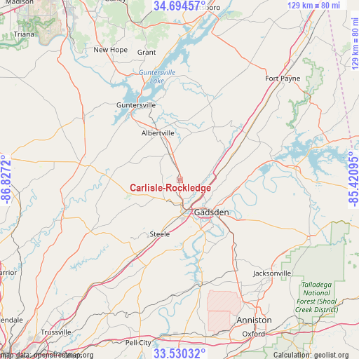
Carlisle-Rockledge GPS coordinates[2]
34° 6' 52.02" North, 86° 7' 26.652" West
| Map corner | latitude | longitude |
|---|---|---|
| Upper-left | 34.69457°, | -86.8272° |
| Center: | 34.11445°, | -86.12407° |
| Lower-right: | 33.53032°, | -85.42095° |
| Map W x H: | 129.5×129.5 km | = 80.5×80.5mi |
| max Lat: | 71.29058° ⇑79.5% North |
| Carlisle-Rockledge: | 34.11445° |
| min Lat: | ⇓20.5% South 19.06759° |
| min Long | Carlisle-Rockle | max Long |
| -171.73463° | -86.12407° | -66.98998° |
| W 52.6%⇐ | ⇒47.4% E |
Elevation
Elevation of Carlisle-Rockledge is 331 m = 1086 ft, and this is 36.2 m = 119 ft above average elevation for this country.
| Max E: |
3189 m = 10463 ft | 22.6% |
| Carlisle-Rockledge | 331 m 1086 ft | |
| Avg. | 294.8 m = 967 ft | |
Min E: |
-60 m = -197 ft | 77.4% |
See also: United States elevation on elevation.city.
Geographical zone
Carlisle-Rockledge is located in North temperate zone (between Tropic of Cancer and the Arctic Circle). Distance of this Northern Tropic circle is 1187.3 km =737.8 mi to South.| Distance of | km | miles | from Carlisle-Rockledge |
|---|---|---|---|
| North Pole | 6213.9 | 3861.1 | to North |
| Arctic Circle | 3608 | 2241.9 | to North |
| Tropic Cancer | 1187.3 | 737.8 | to South |
| Equator | 3793.2 | 2357 | to South |


Nearby cities:
15 places around Carlisle-Rockledge: (largest is in red/bold)
• Albertville
18.7 km =11.6 mi,  335°
335°
• Altoona
21 km =13 mi,  242°
242°
• Attalla
10.8 km =6.7 mi,  162°
162°
• Boaz
10.3 km =6.4 mi, 337°
• Douglas
19.5 km =12.1 mi,  289°
289°
• Egypt
5.4 km =3.4 mi,  212°
212°
• Gadsden
15.5 km =9.6 mi,  135°
135°
• Gallant
17 km =10.6 mi,  220°
220°
• Ivalee
9.1 km =5.7 mi,  192°
192°
• Rainbow City
19.3 km =12 mi, 156°
• Reece City
9.6 km =6 mi,  119°
119°
• Sardis City
6.7 km =4.2 mi,  1°
1°
• Steele
20.7 km =12.9 mi,  200°
200°
• Walnut Grove
17.6 km =10.9 mi,  252°
252°
• Whitesboro
7.4 km =4.6 mi,  42°
42°
Sources, notices
• [Note1] Compared only with cities in United States existing in our database
• [Src1] Map data: © OpenStreetMap contributors (CC-BY-SA)
• [Src2] Other city data from geonames.org with taken over terms of usage.
• [Src3] Geographical zone / Annual Mean Temperature by Robert A. Rohde @ Wikipedia
