Pajarito Mesa geodata
Pajarito Mesa (New Mexico) is a populated place; located in United States in America/Denver (GMT-6) time zone. With population of 579 people, there are 19929 cities with bigger population in this country. Compared to other cities in United States, 75.5% of cities are located further ↑North; 84.6% of cities are located further →East and 97.7% of cities have lower elevation than Pajarito Mesa. Note1


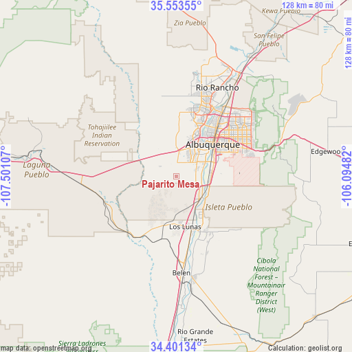
Pajarito Mesa GPS coordinates[2]
34° 58' 46.092" North, 106° 47' 52.584" West
| Map corner | latitude | longitude |
|---|---|---|
| Upper-left | 35.55355°, | -107.50107° |
| Center: | 34.97947°, | -106.79794° |
| Lower-right: | 34.40134°, | -106.09482° |
| Map W x H: | 128.1×128.1 km | = 79.6×79.6mi |
| max Lat: | 71.29058° ⇑75.5% North |
| Pajarito Mesa: | 34.97947° |
| min Lat: | ⇓24.5% South 19.06759° |
| min Long | Pajarito Mesa | max Long |
| -171.73463° | -106.79794° | -66.98998° |
| W 15.4%⇐ | ⇒84.6% E |
Elevation
Elevation of Pajarito Mesa is 1657 m = 5436 ft, and this is 1362.2 m = 4469 ft above average elevation for this country.
| Max E: |
3189 m = 10463 ft | 2.3% |
| Pajarito Mesa | 1657 m 5436 ft | |
| Avg. | 294.8 m = 967 ft | |
Min E: |
-60 m = -197 ft | 97.7% |
See also: United States elevation on elevation.city.
Geographical zone
Pajarito Mesa is located in North temperate zone (between Tropic of Cancer and the Arctic Circle). Distance of this Northern Tropic circle is 1283.4 km =797.5 mi to South.| Distance of | km | miles | from Pajarito Mesa |
|---|---|---|---|
| North Pole | 6117.7 | 3801.4 | to North |
| Arctic Circle | 3511.8 | 2182.1 | to North |
| Tropic Cancer | 1283.4 | 797.5 | to South |
| Equator | 3889.4 | 2416.8 | to South |


Nearby cities:
15 places around Pajarito Mesa: (largest is in red/bold)
• Albuquerque
17.7 km =11 mi,  48°
48°
• Bosque Farms
16.2 km =10.1 mi,  148°
148°
• El Cerro
29.2 km =18.1 mi,  164°
164°
• El Cerro Mission
27.9 km =17.3 mi, 149°
• Lee Acres
23.3 km =14.5 mi,  36°
36°
• Los Chavez
28.5 km =17.7 mi,  172°
172°
• Los Lunas
20.1 km =12.5 mi, 163°
• Los Ranchos de Albuquerque
24.7 km =15.3 mi,  34°
34°
• Monterey Park
28.4 km =17.6 mi, 149°
• North Valley
26.8 km =16.7 mi, 36°
• Paradise Hills
26.1 km =16.2 mi,  19°
19°
• Peralta
18.6 km =11.6 mi, 148°
• South Valley
11.4 km =7.1 mi,  72°
72°
• Tome
27.3 km =17 mi, 166°
• Valencia
21.9 km =13.6 mi, 156°
Sources, notices
• [Note1] Compared only with cities in United States existing in our database
• [Src1] Map data: © OpenStreetMap contributors (CC-BY-SA)
• [Src2] Other city data from geonames.org with taken over terms of usage.
• [Src3] Geographical zone / Annual Mean Temperature by Robert A. Rohde @ Wikipedia
