Bothell East geodata
Bothell East (Washington) is a populated place; located in United States in America/Los_Angeles (GMT-7) time zone. With population of 8,018 people, there are 5269 cities with bigger population in this country. Compared to other cities in United States, 98.3% of cities are located further ↓South; 95.6% of cities are located further →East and 66.9% of cities have higher elevation than Bothell East. Note1


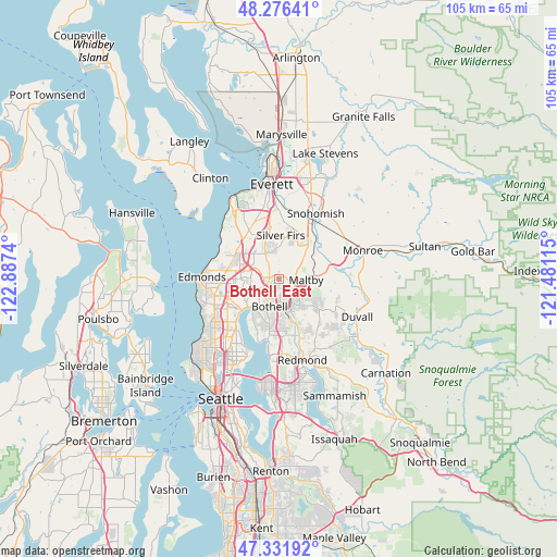
Bothell East GPS coordinates[2]
47° 48' 22.716" North, 122° 11' 3.372" West
| Map corner | latitude | longitude |
|---|---|---|
| Upper-left | 48.27641°, | -122.8874° |
| Center: | 47.80631°, | -122.18427° |
| Lower-right: | 47.33192°, | -121.48115° |
| Map W x H: | 105×105 km | = 65.2×65.2mi |
| max Lat: | 71.29058° ⇑1.7% North |
| Bothell East: | 47.80631° |
| min Lat: | ⇓98.3% South 19.06759° |
| min Long | Bothell East | max Long |
| -171.73463° | -122.18427° | -66.98998° |
| W 4.4%⇐ | ⇒95.6% E |
Elevation
Elevation of Bothell East is 118 m = 387 ft, and this is 176.8 m = 580 ft below average elevation for this country.
| Max E: |
3189 m = 10463 ft | 66.9% |
| Avg. | 294.8 m = 967 ft | |
| Bothell East | 118 m = 387 ft | |
Min E: |
-60 m = -197 ft | 33.1% |
See also: United States elevation on elevation.city.
Geographical zone
Bothell East is located in North temperate zone (between Tropic of Cancer and the Arctic Circle). Distance of this North polar circle is 2085.6 km =1295.9 mi to North.| Distance of | km | miles | from Bothell East |
|---|---|---|---|
| North Pole | 4691.5 | 2915.2 | to North |
| Arctic Circle | 2085.6 | 1295.9 | to North |
| Tropic Cancer | 2709.6 | 1683.7 | to South |
| Equator | 5315.6 | 3303 | to South |


Nearby cities:
15 places around Bothell East: (largest is in red/bold)
• Alderwood Manor
7.5 km =4.7 mi,  283°
283°
• Bothell
5.1 km =3.2 mi,  197°
197°
• Bothell West
4.2 km =2.6 mi,  268°
268°
• Brier
7.1 km =4.4 mi,  250°
250°
• Cathcart
7.8 km =4.8 mi,  53°
53°
• Clearview
5.3 km =3.3 mi,  55°
55°
• Kenmore
7 km =4.3 mi,  219°
219°
• Larch Way
6.5 km =4 mi,  308°
308°
• Maltby
5.3 km =3.3 mi,  91°
91°
• Martha Lake
6.4 km =4 mi,  320°
320°
• Mill Creek
6.2 km =3.9 mi,  345°
345°
• Mill Creek East
3.3 km =2.1 mi,  355°
355°
• North Creek
1.6 km =1 mi,  22°
22°
• Silver Firs
7 km =4.3 mi, 18°
• Woodinville
6 km =3.7 mi,  164°
164°
Sources, notices
• [Note1] Compared only with cities in United States existing in our database
• [Src1] Map data: © OpenStreetMap contributors (CC-BY-SA)
• [Src2] Other city data from geonames.org with taken over terms of usage.
• [Src3] Geographical zone / Annual Mean Temperature by Robert A. Rohde @ Wikipedia
