Bridgewater geodata
Bridgewater (New Jersey) is a populated place; located in United States in America/New_York (GMT-4) time zone. With population of 44,464 people, there are 1072 cities with bigger population in this country. Compared to other cities in United States, 60% of cities are located further ↓South; 88.1% of cities are located further ←West and 77.7% of cities have higher elevation than Bridgewater. Note1
Administrative division(s):
- Level 1: New Jersey
- Level 2: Somerset County
- Level 3: Township of Bridgewater


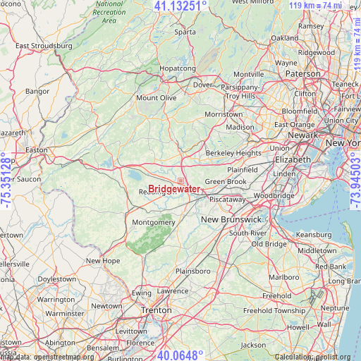
Bridgewater GPS coordinates[2]
40° 36' 2.844" North, 74° 38' 53.34" West
| Map corner | latitude | longitude |
|---|---|---|
| Upper-left | 41.13251°, | -75.35128° |
| Center: | 40.60079°, | -74.64815° |
| Lower-right: | 40.0648°, | -73.94503° |
| Map W x H: | 118.7×118.7 km | = 73.8×73.8mi |
| max Lat: | 71.29058° ⇑40% North |
| Bridgewater: | 40.60079° |
| min Lat: | ⇓60% South 19.06759° |
| min Long | Bridgewater | max Long |
| -171.73463° | -74.64815° | -66.98998° |
| W 88.1%⇐ | ⇒11.9% E |
Elevation
Elevation of Bridgewater is 57 m = 187 ft, and this is 237.8 m = 780 ft below average elevation for this country.
| Max E: |
3189 m = 10463 ft | 77.7% |
| Avg. | 294.8 m = 967 ft | |
| Bridgewater | 57 m = 187 ft | |
Min E: |
-60 m = -197 ft | 22.3% |
See also: Bridgewater elevation on elevation.city.
Geographical zone
Bridgewater is located in North temperate zone (between Tropic of Cancer and the Arctic Circle). Distance of this Northern Tropic circle is 1908.5 km =1185.9 mi to South.| Distance of | km | miles | from Bridgewater |
|---|---|---|---|
| North Pole | 5492.7 | 3413 | to North |
| Arctic Circle | 2886.8 | 1793.8 | to North |
| Tropic Cancer | 1908.5 | 1185.9 | to South |
| Equator | 4514.4 | 2805.1 | to South |


Nearby cities:
15 places around Bridgewater: (largest is in red/bold)
• Bedminster
8.9 km =5.5 mi,  1°
1°
• Borough of Far Hills
10.2 km =6.3 mi,  12°
12°
• Bound Brook
9.9 km =6.2 mi,  111°
111°
• Bradley Gardens
4.3 km =2.7 mi,  187°
187°
• Far Hills
9.3 km =5.8 mi, 6°
• Finderne
7.3 km =4.5 mi,  125°
125°
• Green Knoll
3 km =1.9 mi,  91°
91°
• Manville
8.4 km =5.2 mi,  142°
142°
• Martinsville
7.5 km =4.7 mi, 89°
• Raritan
3.7 km =2.3 mi,  159°
159°
• Somerville
4.4 km =2.7 mi, 132°
• South Bound Brook
11.2 km =7 mi,  118°
118°
• Warren Township
11 km =6.8 mi, 85°
• Weston
8.8 km =5.5 mi,  146°
146°
• Whitehouse Station
10.4 km =6.5 mi,  278°
278°
Sources, notices
• [Note1] Compared only with cities in United States existing in our database
• [Src1] Map data: © OpenStreetMap contributors (CC-BY-SA)
• [Src2] Other city data from geonames.org with taken over terms of usage.
• [Src3] Geographical zone / Annual Mean Temperature by Robert A. Rohde @ Wikipedia
