Fairfield Heights geodata
Fairfield Heights (Indiana) is a populated place; located in United States in America/Indiana/Indianapolis (GMT-4) time zone. With population of 21,285 people, there are 2370 cities with bigger population in this country. Compared to other cities in United States, 51.8% of cities are located further ↓South; 51.9% of cities are located further ←West and 66.7% of cities have lower elevation than Fairfield Heights. Note1


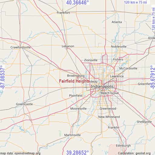
Fairfield Heights GPS coordinates[2]
39° 49' 42.996" North, 86° 22' 56.064" West
| Map corner | latitude | longitude |
|---|---|---|
| Upper-left | 40.36646°, | -87.08537° |
| Center: | 39.82861°, | -86.38224° |
| Lower-right: | 39.28652°, | -85.67912° |
| Map W x H: | 120.1×120.1 km | = 74.6×74.6mi |
| max Lat: | 71.29058° ⇑48.2% North |
| Fairfield Heights: | 39.82861° |
| min Lat: | ⇓51.8% South 19.06759° |
| min Long | Fairfield Heigh | max Long |
| -171.73463° | -86.38224° | -66.98998° |
| W 51.9%⇐ | ⇒48.1% E |
Elevation
Elevation of Fairfield Heights is 270 m = 886 ft, and this is 24.8 m = 81 ft below average elevation for this country.
| Max E: |
3189 m = 10463 ft | 33.3% |
| Avg. | 294.8 m = 967 ft | |
| Fairfield Heights | 270 m = 886 ft | |
Min E: |
-60 m = -197 ft | 66.7% |
See also: United States elevation on elevation.city.
Geographical zone
Fairfield Heights is located in North temperate zone (between Tropic of Cancer and the Arctic Circle). Distance of this Northern Tropic circle is 1822.6 km =1132.5 mi to South.| Distance of | km | miles | from Fairfield Heights |
|---|---|---|---|
| North Pole | 5578.5 | 3466.3 | to North |
| Arctic Circle | 2972.6 | 1847.1 | to North |
| Tropic Cancer | 1822.6 | 1132.5 | to South |
| Equator | 4428.5 | 2751.7 | to South |


Nearby cities:
15 places around Fairfield Heights: (largest is in red/bold)
• Avon
7.5 km =4.7 mi,  191°
191°
• Broad Ripple
21 km =13 mi,  78°
78°
• Brownsburg
2.1 km =1.3 mi,  321°
321°
• Clayton
19.6 km =12.2 mi,  217°
217°
• Clermont
5.5 km =3.4 mi,  112°
112°
• Dale
21 km =13 mi,  355°
355°
• Danville
14.5 km =9 mi,  238°
238°
• Indianapolis
20.3 km =12.6 mi, 109°
• Meridian Hills
20.4 km =12.7 mi,  70°
70°
• Pittsboro
8.2 km =5.1 mi,  298°
298°
• Plainfield
13.9 km =8.6 mi, 186°
• Rocky Ripple
18 km =11.2 mi, 83°
• Speedway
10.3 km =6.4 mi, 106°
• Whitestown
19 km =11.8 mi,  9°
9°
• Zionsville
17 km =10.6 mi,  37°
37°
Sources, notices
• [Note1] Compared only with cities in United States existing in our database
• [Src1] Map data: © OpenStreetMap contributors (CC-BY-SA)
• [Src2] Other city data from geonames.org with taken over terms of usage.
• [Src3] Geographical zone / Annual Mean Temperature by Robert A. Rohde @ Wikipedia
