Whitestown geodata
Whitestown (Indiana) is a populated place; located in United States in America/Indiana/Indianapolis (GMT-4) time zone. With population of 6,013 people, there are 6397 cities with bigger population in this country. Compared to other cities in United States, 53.6% of cities are located further ↓South; 52% of cities are located further ←West and 70.3% of cities have lower elevation than Whitestown. Note1


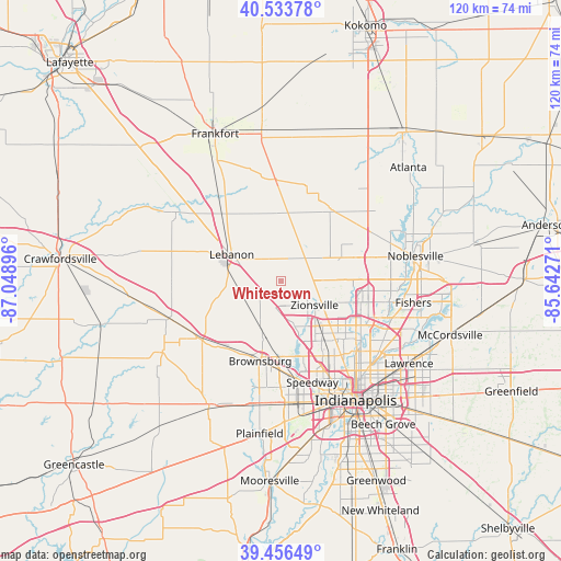
Whitestown GPS coordinates[2]
39° 59' 50.136" North, 86° 20' 44.988" West
| Map corner | latitude | longitude |
|---|---|---|
| Upper-left | 40.53378°, | -87.04896° |
| Center: | 39.99726°, | -86.34583° |
| Lower-right: | 39.45649°, | -85.64271° |
| Map W x H: | 119.8×119.8 km | = 74.4×74.4mi |
| max Lat: | 71.29058° ⇑46.4% North |
| Whitestown: | 39.99726° |
| min Lat: | ⇓53.6% South 19.06759° |
| min Long | Whitestown | max Long |
| -171.73463° | -86.34583° | -66.98998° |
| W 52%⇐ | ⇒48% E |
Elevation
Elevation of Whitestown is 287 m = 942 ft, and this is 7.8 m = 26 ft below average elevation for this country.
| Max E: |
3189 m = 10463 ft | 29.7% |
| Avg. | 294.8 m = 967 ft | |
| Whitestown | 287 m = 942 ft | |
Min E: |
-60 m = -197 ft | 70.3% |
See also: United States elevation on elevation.city.
Geographical zone
Whitestown is located in North temperate zone (between Tropic of Cancer and the Arctic Circle). Distance of this Northern Tropic circle is 1841.4 km =1144.2 mi to South.| Distance of | km | miles | from Whitestown |
|---|---|---|---|
| North Pole | 5559.8 | 3454.7 | to North |
| Arctic Circle | 2953.9 | 1835.5 | to North |
| Tropic Cancer | 1841.4 | 1144.2 | to South |
| Equator | 4447.3 | 2763.4 | to South |


Nearby cities:
15 places around Whitestown: (largest is in red/bold)
• Broad Ripple
22.7 km =14.1 mi,  129°
129°
• Brownsburg
17.7 km =11 mi,  194°
194°
• Carmel
19.5 km =12.1 mi,  96°
96°
• Clermont
20.9 km =13 mi,  174°
174°
• Dale
5.1 km =3.2 mi,  295°
295°
• Fairfield Heights
19 km =11.8 mi, 189°
• Kirklin
21.8 km =13.5 mi,  356°
356°
• Lebanon
11.9 km =7.4 mi, 298°
• Meridian Hills
20 km =12.4 mi, 126°
• Pittsboro
18.1 km =11.2 mi,  214°
214°
• Rocky Ripple
22.2 km =13.8 mi,  138°
138°
• Sheridan
18.7 km =11.6 mi,  34°
34°
• Speedway
22.7 km =14.1 mi,  162°
162°
• Westfield
19.3 km =12 mi,  74°
74°
• Zionsville
8.8 km =5.5 mi, 125°
Sources, notices
• [Note1] Compared only with cities in United States existing in our database
• [Src1] Map data: © OpenStreetMap contributors (CC-BY-SA)
• [Src2] Other city data from geonames.org with taken over terms of usage.
• [Src3] Geographical zone / Annual Mean Temperature by Robert A. Rohde @ Wikipedia
