Shoal Creek geodata
Shoal Creek (Alabama) is a populated place; located in United States in America/Chicago (GMT-5) time zone. With population of 1,400 people, there are 14111 cities with bigger population in this country. Compared to other cities in United States, 83.5% of cities are located further ↑North; 51.3% of cities are located further ←West and 64.1% of cities have lower elevation than Shoal Creek. Note1


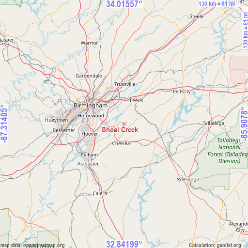
Shoal Creek GPS coordinates[2]
33° 25' 50.736" North, 86° 36' 39.312" West
| Map corner | latitude | longitude |
|---|---|---|
| Upper-left | 34.01557°, | -87.31405° |
| Center: | 33.43076°, | -86.61092° |
| Lower-right: | 32.84199°, | -85.9078° |
| Map W x H: | 130.5×130.5 km | = 81.1×81.1mi |
| max Lat: | 71.29058° ⇑83.5% North |
| Shoal Creek: | 33.43076° |
| min Lat: | ⇓16.5% South 19.06759° |
| min Long | Shoal Creek | max Long |
| -171.73463° | -86.61092° | -66.98998° |
| W 51.3%⇐ | ⇒48.7% E |
Elevation
Elevation of Shoal Creek is 258 m = 846 ft, and this is 36.8 m = 121 ft below average elevation for this country.
| Max E: |
3189 m = 10463 ft | 35.9% |
| Avg. | 294.8 m = 967 ft | |
| Shoal Creek | 258 m = 846 ft | |
Min E: |
-60 m = -197 ft | 64.1% |
See also: United States elevation on elevation.city.
Geographical zone
Shoal Creek is located in North temperate zone (between Tropic of Cancer and the Arctic Circle). Distance of this Northern Tropic circle is 1111.2 km =690.5 mi to South.| Distance of | km | miles | from Shoal Creek |
|---|---|---|---|
| North Pole | 6289.9 | 3908.4 | to North |
| Arctic Circle | 3684 | 2289.1 | to North |
| Tropic Cancer | 1111.2 | 690.5 | to South |
| Equator | 3717.2 | 2309.8 | to South |


Nearby cities:
15 places around Shoal Creek: (largest is in red/bold)
• Brook Highland
5.9 km =3.7 mi,  275°
275°
• Cahaba Heights
11.8 km =7.3 mi,  288°
288°
• Chelsea
10.2 km =6.3 mi,  190°
190°
• Dunnavant
9.3 km =5.8 mi,  41°
41°
• Highland Lakes
5.2 km =3.2 mi,  226°
226°
• Indian Springs Village
15.7 km =9.8 mi,  237°
237°
• Irondale
14.9 km =9.3 mi,  323°
323°
• Lake Purdy
6.5 km =4 mi,  269°
269°
• Leeds
14.4 km =8.9 mi,  25°
25°
• Meadowbrook
8.6 km =5.3 mi,  248°
248°
• Mountain Brook
15.3 km =9.5 mi,  300°
300°
• Sterrett
12.3 km =7.6 mi,  80°
80°
• Vandiver
10.1 km =6.3 mi,  63°
63°
• Vestavia Hills
16.5 km =10.3 mi, 276°
• Westover
11.4 km =7.1 mi,  142°
142°
Sources, notices
• [Note1] Compared only with cities in United States existing in our database
• [Src1] Map data: © OpenStreetMap contributors (CC-BY-SA)
• [Src2] Other city data from geonames.org with taken over terms of usage.
• [Src3] Geographical zone / Annual Mean Temperature by Robert A. Rohde @ Wikipedia
