Machiques geodata
Machiques (Zulia) is a seat of a second-order administrative division; located in Venezuela in America/Caracas (GMT-4) time zone. With population of 62,968 people, there are 61 cities with bigger population in this country. Compared to other cities in Venezuela, 60.1% of cities are located further ↓South; 100% of cities are located further →East and 66.2% of cities have higher elevation than Machiques. Note1


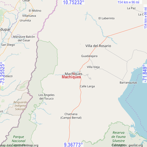
Machiques GPS coordinates[2]
10° 3' 38.772" North, 72° 33' 7.632" West
| Map corner | latitude | longitude |
|---|---|---|
| Upper-left | 10.75232°, | -73.25525° |
| Center: | 10.06077°, | -72.55212° |
| Lower-right: | 9.36773°, | -71.849° |
| Map W x H: | 154×154 km | = 95.7×95.7mi |
| max Lat: | 11.94788° ⇑39.9% North |
| Machiques: | 10.06077° |
| min Lat: | ⇓60.1% South 1.92027° |
| min Long | Machiques | max Long |
| -72.55212° | -72.55212° | -60.99778° |
| W 0%⇐ | ⇒100% E |
Elevation
Elevation of Machiques is 99 m = 325 ft, and this is 281.6 m = 924 ft below average elevation for this country.
| Max E: |
2986 m = 9797 ft | 66.2% |
| Avg. | 380.6 m = 1249 ft | |
| Machiques | 99 m = 325 ft | |
Min E: |
-4 m = -13 ft | 33.8% |
See also: Machiques elevation on elevation.city.
Geographical zone
Machiques is located in North Torrid zone (between Equator and Tropic of Cancer). Distance of Equator is 1118.7 km =695.1 mi to South.| Distance of | km | miles | from Machiques |
|---|---|---|---|
| North Pole | 8888.4 | 5523 | to North |
| Arctic Circle | 6282.5 | 3903.8 | to North |
| Tropic Cancer | 1487.3 | 924.2 | to North |
| Equator | 1118.7 | 695.1 | to South |


Nearby cities:
15 places around Machiques: (largest is in red/bold)
• Cabimas
126.1 km =78.4 mi,  72°
72°
• Ciudad Ojeda
136.3 km =84.7 mi,  83°
83°
• Concepción
102.2 km =63.5 mi, 67°
• Concepción
118.9 km =73.9 mi,  46°
46°
• El Toro
140.1 km =87.1 mi,  44°
44°
• Encontrados
116.6 km =72.5 mi,  162°
162°
• La Concepción
99.8 km =62 mi, 51°
• La Villa del Rosario
39.4 km =24.5 mi, 41°
• Los Puertos de Altagracia
134.1 km =83.3 mi,  57°
57°
• Maracaibo
122.9 km =76.4 mi, 56°
• San Carlos del Zulia
136.3 km =84.7 mi,  149°
149°
• San Francisco
107.8 km =67 mi, 59°
• Santa Rita
125.6 km =78 mi, 65°
• Sinamaica
137.1 km =85.2 mi,  33°
33°
• Tía Juana
132 km =82 mi, 80°
Sources, notices
• [Note1] Compared only with cities in Venezuela existing in our database
• [Src1] Map data: © OpenStreetMap contributors (CC-BY-SA)
• [Src2] Other city data from geonames.org with taken over terms of usage.
• [Src3] Geographical zone / Annual Mean Temperature by Robert A. Rohde @ Wikipedia
