Tía Juana geodata
Tía Juana (Zulia) is a seat of a second-order administrative division; located in Venezuela in America/Caracas (GMT-4) time zone. In our database, there are 108 cities with bigger population. Compared to other cities in Venezuela, 72.3% of cities are located further ↓South; 85% of cities are located further →East and 99.2% of cities have higher elevation than Tía Juana. Note1


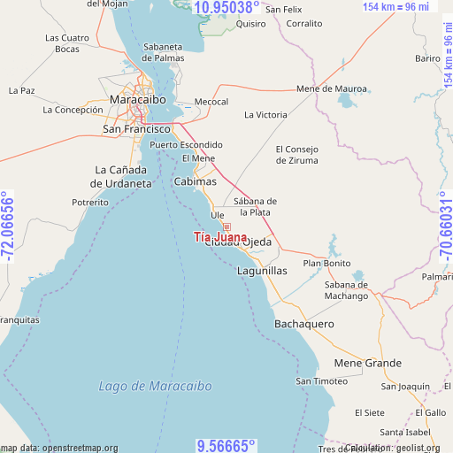
Tía Juana GPS coordinates[2]
10° 15' 33.372" North, 71° 21' 48.348" West
| Map corner | latitude | longitude |
|---|---|---|
| Upper-left | 10.95038°, | -72.06656° |
| Center: | 10.25927°, | -71.36343° |
| Lower-right: | 9.56665°, | -70.66031° |
| Map W x H: | 153.9×153.9 km | = 95.6×95.6mi |
| max Lat: | 11.94788° ⇑27.7% North |
| Tía Juana: | 10.25927° |
| min Lat: | ⇓72.3% South 1.92027° |
| min Long | Tía Juana | max Long |
| -72.55212° | -71.36343° | -60.99778° |
| W 15%⇐ | ⇒85% E |
Elevation
Elevation of Tía Juana is 1 m = 3 ft, and this is 379.6 m = 1245 ft below average elevation for this country.
| Max E: |
2986 m = 9797 ft | 99.2% |
| Avg. | 380.6 m = 1249 ft | |
| Tía Juana | 1 m = 3 ft | |
Min E: |
-4 m = -13 ft | 0.8% |
See also: Venezuela elevation on elevation.city.
Geographical zone
Tía Juana is located in North Torrid zone (between Equator and Tropic of Cancer). Distance of Equator is 1140.7 km =708.8 mi to South.| Distance of | km | miles | from Tía Juana |
|---|---|---|---|
| North Pole | 8866.3 | 5509.3 | to North |
| Arctic Circle | 6260.5 | 3890.1 | to North |
| Tropic Cancer | 1465.2 | 910.4 | to North |
| Equator | 1140.7 | 708.8 | to South |


Nearby cities:
15 places around Tía Juana: (largest is in red/bold)
• Bachaquero
42.2 km =26.2 mi,  141°
141°
• Cabimas
18.3 km =11.4 mi,  328°
328°
• Ciudad Ojeda
8.3 km =5.2 mi, 140°
• Concepción
39.5 km =24.5 mi,  295°
295°
• Concepción
74.6 km =46.4 mi,  323°
323°
• El Corozo
38.2 km =23.7 mi,  113°
113°
• La Concepción
65.5 km =40.7 mi,  307°
307°
• La Plata
12.1 km =7.5 mi,  55°
55°
• Lagunillas
18.3 km =11.4 mi, 141°
• Los Puertos de Altagracia
53.5 km =33.2 mi,  341°
341°
• Maracaibo
52.8 km =32.8 mi, 328°
• Mene de Mauroa
59 km =36.7 mi,  37°
37°
• San Francisco
49.6 km =30.8 mi, 311°
• San Timoteo
61.2 km =38 mi,  148°
148°
• Santa Rita
34.8 km =21.6 mi, 332°
Sources, notices
• [Note1] Compared only with cities in Venezuela existing in our database
• [Src1] Map data: © OpenStreetMap contributors (CC-BY-SA)
• [Src2] Other city data from geonames.org with taken over terms of usage.
• [Src3] Geographical zone / Annual Mean Temperature by Robert A. Rohde @ Wikipedia
