Thanh Chương geodata
Thanh Chương (Nghệ An) is a seat of a second-order administrative division; located in Vietnam in Asia/Ho_Chi_Minh (GMT+7) time zone. In our database, there are 94 cities with bigger population. Compared to other cities in Vietnam, 54.5% of cities are located further ↓South; 82.1% of cities are located further →East and 59.2% of cities have lower elevation than Thanh Chương. Note1


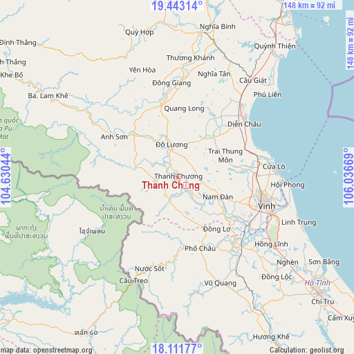
Thanh Chương GPS coordinates[2]
18° 46' 43.572" North, 105° 20' 0.816" East
| Map corner | latitude | longitude |
|---|---|---|
| Upper-left | 19.44314°, | 104.63044° |
| Center: | 18.77877°, | 105.33356° |
| Lower-right: | 18.11177°, | 106.03669° |
| Map W x H: | 148×148 km | = 92×92mi |
| max Lat: | 23.27841° ⇑45.5% North |
| Thanh Chương: | 18.77877° |
| min Lat: | ⇓54.5% South 8.65724° |
| min Long | Thanh Chương | max Long |
| 102.4579° | 105.33356° | 112.72541° |
| W 17.9%⇐ | ⇒82.1% E |
Elevation
Elevation of Thanh Chương is 22 m = 72 ft, and this is 107.5 m = 353 ft below average elevation for this country.
| Max E: |
1592 m = 5223 ft | 40.8% |
| Avg. | 129.5 m = 425 ft | |
| Thanh Chương | 22 m = 72 ft | |
Min E: |
-1 m = -3 ft | 59.2% |
See also: Vietnam elevation on elevation.city.
Geographical zone
Thanh Chương is located in North Torrid zone (between Equator and Tropic of Cancer). Distance of this Northern Tropic circle is 517.9 km =321.8 mi to North.| Distance of | km | miles | from Thanh Chương |
|---|---|---|---|
| North Pole | 7919.1 | 4920.7 | to North |
| Arctic Circle | 5313.2 | 3301.5 | to North |
| Tropic Cancer | 517.9 | 321.8 | to North |
| Equator | 2088 | 1297.4 | to South |


Nearby cities:
15 places around Thanh Chương: (largest is in red/bold)
• Anh Son
36.2 km =22.5 mi,  305°
305°
• Con Cuông
56.3 km =35 mi,  302°
302°
• Cầu Giát
51.4 km =31.9 mi,  37°
37°
• Diễn Châu
35.7 km =22.2 mi,  51°
51°
• Hưng Nguyên
33.3 km =20.7 mi,  110°
110°
• Nam Đàn
19.6 km =12.2 mi,  117°
117°
• Nghi Xuân
46.3 km =28.8 mi, 106°
• Phố Châu
31 km =19.3 mi,  162°
162°
• Quán Hành
32.9 km =20.4 mi,  89°
89°
• Tân Kỳ
30.7 km =19.1 mi,  347°
347°
• Vinh
39.6 km =24.6 mi, 107°
• Vũ Quang
47.5 km =29.5 mi, 157°
• Yên Thành
28.4 km =17.6 mi,  30°
30°
• Yên Vinh
37.2 km =23.1 mi, 109°
• Đức Thọ
37.4 km =23.2 mi,  135°
135°
Sources, notices
• [Note1] Compared only with cities in Vietnam existing in our database
• [Src1] Map data: © OpenStreetMap contributors (CC-BY-SA)
• [Src2] Other city data from geonames.org with taken over terms of usage.
• [Src3] Geographical zone / Annual Mean Temperature by Robert A. Rohde @ Wikipedia
