Vinh geodata
Vinh (Nghệ An) is a seat of a first-order administrative division; located in Vietnam in Asia/Ho_Chi_Minh (GMT+7) time zone. With population of 163,759 people, there are 15 cities with bigger population in this country. Compared to other cities in Vietnam, 54.2% of cities are located further ↓South; 68.8% of cities are located further →East and 54.8% of cities have higher elevation than Vinh. Note1


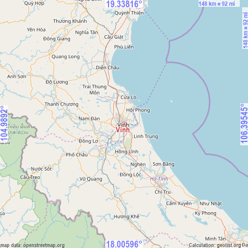
Vinh GPS coordinates[2]
18° 40' 24.132" North, 105° 41' 32.352" East
| Map corner | latitude | longitude |
|---|---|---|
| Upper-left | 19.33816°, | 104.9892° |
| Center: | 18.67337°, | 105.69232° |
| Lower-right: | 18.00596°, | 106.39545° |
| Map W x H: | 148.1×148.1 km | = 92×92mi |
| max Lat: | 23.27841° ⇑45.8% North |
| Vinh: | 18.67337° |
| min Lat: | ⇓54.2% South 8.65724° |
| min Long | Vinh | max Long |
| 102.4579° | 105.69232° | 112.72541° |
| W 31.2%⇐ | ⇒68.8% E |
Elevation
Elevation of Vinh is 12 m = 39 ft, and this is 117.5 m = 385 ft below average elevation for this country.
| Max E: |
1592 m = 5223 ft | 54.8% |
| Avg. | 129.5 m = 425 ft | |
| Vinh | 12 m = 39 ft | |
Min E: |
-1 m = -3 ft | 45.2% |
See also: Vinh elevation on elevation.city.
Geographical zone
Vinh is located in North Torrid zone (between Equator and Tropic of Cancer). Distance of this Northern Tropic circle is 529.6 km =329.1 mi to North.| Distance of | km | miles | from Vinh |
|---|---|---|---|
| North Pole | 7930.8 | 4928 | to North |
| Arctic Circle | 5324.9 | 3308.7 | to North |
| Tropic Cancer | 529.6 | 329.1 | to North |
| Equator | 2076.3 | 1290.2 | to South |


Nearby cities:
15 places around Vinh: (largest is in red/bold)
• Cầu Giát
52.9 km =32.9 mi,  352°
352°
• Diễn Châu
35.1 km =21.8 mi,  343°
343°
• Hà Tĩnh
43.1 km =26.8 mi,  148°
148°
• Hưng Nguyên
6.7 km =4.2 mi,  268°
268°
• Nam Đàn
20.6 km =12.8 mi,  277°
277°
• Nghi Xuân
6.8 km =4.2 mi,  100°
100°
• Nghèn
26.4 km =16.4 mi,  159°
159°
• Phố Châu
33.4 km =20.8 mi,  237°
237°
• Quán Hành
12.7 km =7.9 mi, 337°
• Thanh Chương
39.6 km =24.6 mi,  287°
287°
• Thạch Hà
38.4 km =23.9 mi, 152°
• Vũ Quang
37.7 km =23.4 mi,  211°
211°
• Yên Thành
43 km =26.7 mi,  327°
327°
• Yên Vinh
2.8 km =1.7 mi,  254°
254°
• Đức Thọ
18.8 km =11.7 mi,  217°
217°
Sources, notices
• [Note1] Compared only with cities in Vietnam existing in our database
• [Src1] Map data: © OpenStreetMap contributors (CC-BY-SA)
• [Src2] Other city data from geonames.org with taken over terms of usage.
• [Src3] Geographical zone / Annual Mean Temperature by Robert A. Rohde @ Wikipedia
