Apia geodata
Apia (Tuamasaga) is a capital of a political entity; located in Samoa in Pacific/Apia (GMT+13) time zone. With population of 40,407 people, there are 0 cities with bigger population in this country. Compared to other cities in Samoa, 57.4% of cities are located further ↑North; 68.9% of cities are located further ←West and 90.2% of cities have higher elevation than Apia. Note1


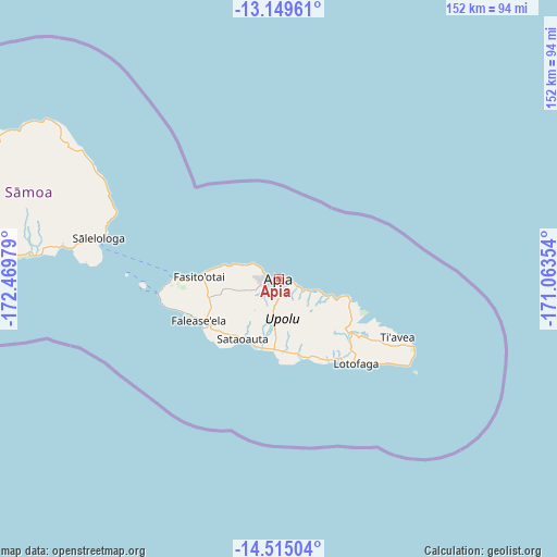
Apia GPS coordinates[2]
13° 49' 59.988" South, 171° 45' 59.976" West
| Map corner | latitude | longitude |
|---|---|---|
| Upper-left | -13.14961°, | -172.46979° |
| Center: | -13.83333°, | -171.76666° |
| Lower-right: | -14.51504°, | -171.06354° |
| Map W x H: | 151.8×151.8 km | = 94.3×94.3mi |
| max Lat: | -13.44894° ⇑57.4% North |
| Apia: | -13.83333° |
| min Lat: | ⇓42.6% South -14.04454° |
| min Long | Apia | max Long |
| -172.69436° | -171.76666° | -171.42559° |
| W 68.9%⇐ | ⇒31.1% E |
Elevation
Elevation of Apia is 9 m = 30 ft, and this is 14.9 m = 49 ft below average elevation for this country.
| Max E: |
252 m = 827 ft | 90.2% |
| Avg. | 23.9 m = 78 ft | |
| Apia | 9 m = 30 ft | |
Min E: |
7 m = 23 ft | 9.8% |
See also: Apia elevation on elevation.city.
Geographical zone
Apia is located in South Torrid zone (between Equator and Tropic of Capricorn). Distance of this Southern Tropic circle is 1067.8 km =663.5 mi to South.| Distance of | km | miles | from Apia |
|---|---|---|---|
| Equator | 1538.1 | 955.7 | to North |
| Tropic Capricorn | 1067.8 | 663.5 | to South |
| Antarctic Circle | 5863.1 | 3643.2 | to South |
| South Pole | 8468.9 | 5262.3 | to South |


Nearby cities:
15 places around Apia: (largest is in red/bold)
• Afega
10.2 km =6.3 mi,  293°
293°
• Faleula
8.2 km =5.1 mi,  301°
301°
• Fusi
16.7 km =10.4 mi,  110°
110°
• Lepea
2.5 km =1.6 mi,  263°
263°
• Letogo
5.3 km =3.3 mi, 113°
• Malie
9.4 km =5.8 mi, 292°
• Salepou‘a‘e
14.2 km =8.8 mi,  283°
283°
• Sapulu
17.1 km =10.6 mi, 280°
• Siusega
5.3 km =3.3 mi, 256°
• Solosolo
14.3 km =8.9 mi, 108°
• Toamua
5.7 km =3.5 mi, 300°
• Tufulele
16.4 km =10.2 mi, 281°
• Vaigaga
3.2 km =2 mi, 289°
• Vailima
3.5 km =2.2 mi,  170°
170°
• Vaiusu
3 km =1.9 mi, 284°
Sources, notices
• [Note1] Compared only with cities in Samoa existing in our database
• [Src1] Map data: © OpenStreetMap contributors (CC-BY-SA)
• [Src2] Other city data from geonames.org with taken over terms of usage.
• [Src3] Geographical zone / Annual Mean Temperature by Robert A. Rohde @ Wikipedia
