Shtime geodata
Shtime (Ferizaj) is a seat of a second-order administrative division; located in Kosovo in Europe/Belgrade (GMT+2) time zone. With population of 35,000 people, there are 12 cities with bigger population in this country. Compared to other cities in Kosovo, 69.2% of cities are located further ↑North; 72.3% of cities are located further ←West and 66.2% of cities have lower elevation than Shtime. Note1


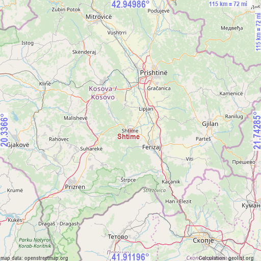
Shtime GPS coordinates[2]
42° 25' 59.016" North, 21° 2' 22.992" East
| Map corner | latitude | longitude |
|---|---|---|
| Upper-left | 42.94986°, | 20.3366° |
| Center: | 42.43306°, | 21.03972° |
| Lower-right: | 41.91196°, | 21.74285° |
| Map W x H: | 115.4×115.4 km | = 71.7×71.7mi |
| max Lat: | 43.10389° ⇑69.2% North |
| Shtime: | 42.43306° |
| min Lat: | ⇓30.8% South 42.0265° |
| min Long | Shtime | max Long |
| 20.27722° | 21.03972° | 21.59889° |
| W 72.3%⇐ | ⇒27.7% E |
Elevation
Elevation of Shtime is 572 m = 1877 ft, and this is 27.4 m = 90 ft above average elevation for this country.
| Max E: |
1062 m = 3484 ft | 33.8% |
| Shtime | 572 m 1877 ft | |
| Avg. | 544.6 m = 1787 ft | |
Min E: |
333 m = 1093 ft | 66.2% |
See also: Kosovo elevation on elevation.city.
Geographical zone
Shtime is located in North temperate zone (between Tropic of Cancer and the Arctic Circle). Distance of this Northern Tropic circle is 2112.2 km =1312.5 mi to South.| Distance of | km | miles | from Shtime |
|---|---|---|---|
| North Pole | 5288.9 | 3286.4 | to North |
| Arctic Circle | 2683.1 | 1667.2 | to North |
| Tropic Cancer | 2112.2 | 1312.5 | to South |
| Equator | 4718.1 | 2931.7 | to South |


Nearby cities:
15 places around Shtime: (largest is in red/bold)
• Budakovo
12.8 km =8 mi,  227°
227°
• Ferizaj
11.8 km =7.3 mi,  126°
126°
• Gjinoc
22.2 km =13.8 mi, 234°
• Glanica
13.1 km =8.1 mi,  8°
8°
• Glogovac
24.8 km =15.4 mi,  331°
331°
• Gračanica
22.6 km =14 mi,  34°
34°
• Kosovo Polje
26.1 km =16.2 mi, 10°
• Leshan
24.3 km =15.1 mi,  241°
241°
• Lipljan
12.1 km =7.5 mi,  35°
35°
• Mališevo
24.7 km =15.3 mi,  282°
282°
• Nishor
19.6 km =12.2 mi,  267°
267°
• Pagaruša
24.5 km =15.2 mi, 266°
• Peqan
18.7 km =11.6 mi,  252°
252°
• Suva Reka
19.5 km =12.1 mi, 244°
• Štrpce
21.6 km =13.4 mi,  182°
182°
Sources, notices
• [Note1] Compared only with cities in Kosovo existing in our database
• [Src1] Map data: © OpenStreetMap contributors (CC-BY-SA)
• [Src2] Other city data from geonames.org with taken over terms of usage.
• [Src3] Geographical zone / Annual Mean Temperature by Robert A. Rohde @ Wikipedia
