Ferizaj geodata
Ferizaj is a seat of a first-order administrative division; located in Kosovo in Europe/Belgrade (GMT+2) time zone. With population of 59,504 people, there are 5 cities with bigger population in this country. Compared to other cities in Kosovo, 83.1% of cities are located further ↑North; 80% of cities are located further ←West and 69.2% of cities have lower elevation than Ferizaj. Note1


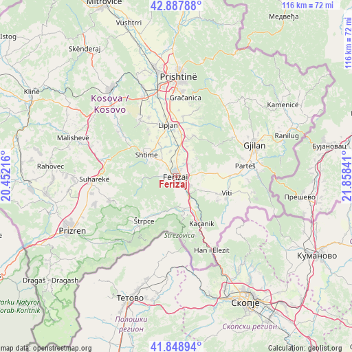
Ferizaj GPS coordinates[2]
42° 22' 14.016" North, 21° 9' 19.008" East
| Map corner | latitude | longitude |
|---|---|---|
| Upper-left | 42.88788°, | 20.45216° |
| Center: | 42.37056°, | 21.15528° |
| Lower-right: | 41.84894°, | 21.85841° |
| Map W x H: | 115.5×115.5 km | = 71.8×71.8mi |
| max Lat: | 43.10389° ⇑83.1% North |
| Ferizaj: | 42.37056° |
| min Lat: | ⇓16.9% South 42.0265° |
| min Long | Ferizaj | max Long |
| 20.27722° | 21.15528° | 21.59889° |
| W 80%⇐ | ⇒20% E |
Elevation
Elevation of Ferizaj is 582 m = 1909 ft, and this is 37.4 m = 123 ft above average elevation for this country.
| Max E: |
1062 m = 3484 ft | 30.8% |
| Ferizaj | 582 m 1909 ft | |
| Avg. | 544.6 m = 1787 ft | |
Min E: |
333 m = 1093 ft | 69.2% |
See also: Ferizaj elevation on elevation.city.
Geographical zone
Ferizaj is located in North temperate zone (between Tropic of Cancer and the Arctic Circle). Distance of this Northern Tropic circle is 2105.2 km =1308.1 mi to South.| Distance of | km | miles | from Ferizaj |
|---|---|---|---|
| North Pole | 5295.9 | 3290.7 | to North |
| Arctic Circle | 2690 | 1671.5 | to North |
| Tropic Cancer | 2105.2 | 1308.1 | to South |
| Equator | 4711.2 | 2927.4 | to South |


Nearby cities:
15 places around Ferizaj: (largest is in red/bold)
• Budakovo
19 km =11.8 mi,  264°
264°
• Gjilan
27.7 km =17.2 mi,  68°
68°
• Glanica
21.3 km =13.2 mi,  339°
339°
• Gračanica
25.8 km =16 mi,  7°
7°
• Hani i Elezit
27.1 km =16.8 mi,  154°
154°
• Kačanik
17.6 km =10.9 mi, 150°
• Klokot
18 km =11.2 mi,  89°
89°
• Lipljan
17 km =10.6 mi,  351°
351°
• Partesh
23.1 km =14.4 mi,  81°
81°
• Pasjane
28.2 km =17.5 mi, 81°
• Peqan
27.4 km =17 mi,  273°
273°
• Shtime
11.8 km =7.3 mi,  306°
306°
• Suva Reka
27.2 km =16.9 mi, 267°
• Vitina
17.6 km =10.9 mi,  108°
108°
• Štrpce
18 km =11.2 mi,  215°
215°
Sources, notices
• [Note1] Compared only with cities in Kosovo existing in our database
• [Src1] Map data: © OpenStreetMap contributors (CC-BY-SA)
• [Src2] Other city data from geonames.org with taken over terms of usage.
• [Src3] Geographical zone / Annual Mean Temperature by Robert A. Rohde @ Wikipedia
