Llazicë geodata
Llazicë (Prizren) is a populated place; located in Kosovo in Europe/Belgrade (GMT+1) time zone. With population of 19,863 people, there are 17 cities with bigger population in this country. Compared to other cities in Kosovo, 61.5% of cities are located further ↓South; 50.8% of cities are located further ←West and 93.8% of cities have lower elevation than Llazicë. Note1


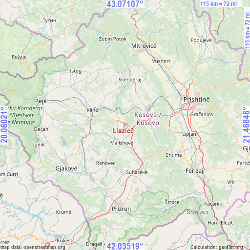
Llazicë GPS coordinates[2]
42° 33' 19.008" North, 20° 45' 47.988" East
| Map corner | latitude | longitude |
|---|---|---|
| Upper-left | 43.07107°, | 20.06021° |
| Center: | 42.55528°, | 20.76333° |
| Lower-right: | 42.03519°, | 21.46646° |
| Map W x H: | 115.2×115.2 km | = 71.6×71.6mi |
| max Lat: | 43.10389° ⇑38.5% North |
| Llazicë: | 42.55528° |
| min Lat: | ⇓61.5% South 42.0265° |
| min Long | Llazicë | max Long |
| 20.27722° | 20.76333° | 21.59889° |
| W 50.8%⇐ | ⇒49.2% E |
Elevation
Elevation of Llazicë is 635 m = 2083 ft, and this is 90.4 m = 297 ft above average elevation for this country.
| Max E: |
1062 m = 3484 ft | 6.2% |
| Llazicë | 635 m 2083 ft | |
| Avg. | 544.6 m = 1787 ft | |
Min E: |
333 m = 1093 ft | 93.8% |
See also: Kosovo elevation on elevation.city.
Geographical zone
Llazicë is located in North temperate zone (between Tropic of Cancer and the Arctic Circle). Distance of this Northern Tropic circle is 2125.8 km =1320.9 mi to South.| Distance of | km | miles | from Llazicë |
|---|---|---|---|
| North Pole | 5275.4 | 3278 | to North |
| Arctic Circle | 2669.5 | 1658.7 | to North |
| Tropic Cancer | 2125.8 | 1320.9 | to South |
| Equator | 4731.7 | 2940.1 | to South |


Nearby cities:
15 places around Llazicë: (largest is in red/bold)
• Budakovo
25.9 km =16.1 mi,  149°
149°
• Buqan
25.4 km =15.8 mi,  270°
270°
• Glanica
24.6 km =15.3 mi,  91°
91°
• Glogovac
13.4 km =8.3 mi,  52°
52°
• Klina
16.9 km =10.5 mi,  295°
295°
• Kosuriq
24.5 km =15.2 mi, 273°
• Leshan
25.3 km =15.7 mi,  176°
176°
• Mališevo
8.2 km =5.1 mi,  190°
190°
• Mamuša
25.1 km =15.6 mi, 186°
• Nishor
14.9 km =9.3 mi,  167°
167°
• Orahovac
19.5 km =12.1 mi,  207°
207°
• Pagaruša
15.1 km =9.4 mi, 186°
• Peqan
19.7 km =12.2 mi, 165°
• Srbica
21.4 km =13.3 mi,  5°
5°
• Suva Reka
22.4 km =13.9 mi, 166°
Sources, notices
• [Note1] Compared only with cities in Kosovo existing in our database
• [Src1] Map data: © OpenStreetMap contributors (CC-BY-SA)
• [Src2] Other city data from geonames.org with taken over terms of usage.
• [Src3] Geographical zone / Annual Mean Temperature by Robert A. Rohde @ Wikipedia
