Ordino geodata
Ordino is a seat of a first-order administrative division; located in Andorra in Europe/Andorra (GMT+2) time zone. With population of 3,066 people, there are 6 cities with bigger population in this country. Compared to other cities in Andorra, 63.6% of cities are located further ↓South; 54.5% of cities are located further →East and 54.5% of cities have higher elevation than Ordino. Note1


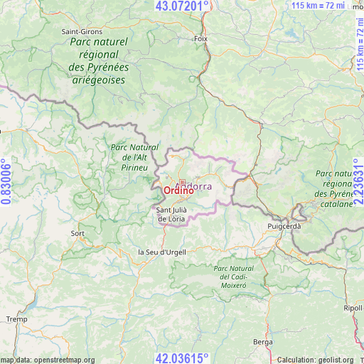
Ordino GPS coordinates[2]
42° 33' 22.428" North, 1° 31' 59.484" East
| Map corner | latitude | longitude |
|---|---|---|
| Upper-left | 43.07201°, | 0.83006° |
| Center: | 42.55623°, | 1.53319° |
| Lower-right: | 42.03615°, | 2.23631° |
| Map W x H: | 115.2×115.2 km | = 71.6×71.6mi |
| max Lat: | 42.57952° ⇑36.4% North |
| Ordino: | 42.55623° |
| min Lat: | ⇓63.6% South 42.46372° |
| min Long | Ordino | max Long |
| 1.48453° | 1.53319° | 1.73361° |
| W 45.5%⇐ | ⇒54.5% E |
Elevation
Elevation of Ordino is 1296 m = 4252 ft, and this is 101.5 m = 333 ft below average elevation for this country.
| Max E: |
2106 m = 6909 ft | 54.5% |
| Avg. | 1397.5 m = 4585 ft | |
| Ordino | 1296 m = 4252 ft | |
Min E: |
921 m = 3022 ft | 45.5% |
See also: Andorra elevation on elevation.city.
Geographical zone
Ordino is located in North temperate zone (between Tropic of Cancer and the Arctic Circle). Distance of this Northern Tropic circle is 2125.9 km =1321 mi to South.| Distance of | km | miles | from Ordino |
|---|---|---|---|
| North Pole | 5275.3 | 3277.9 | to North |
| Arctic Circle | 2669.4 | 1658.7 | to North |
| Tropic Cancer | 2125.9 | 1321 | to South |
| Equator | 4731.8 | 2940.2 | to South |


Nearby cities:
11 places around Ordino: (largest is in red/bold)
• Andorra la Vella
5.5 km =3.4 mi,  190°
190°
• Arinsal
4.4 km =2.7 mi,  293°
293°
• Canillo
5.4 km =3.4 mi,  76°
76°
• El Tarter
10.2 km =6.3 mi, 75°
• Encamp
4.5 km =2.8 mi,  121°
121°
• Pas de la Casa
16.5 km =10.3 mi,  95°
95°
• Sant Julià de Lòria
10.8 km =6.7 mi,  198°
198°
• Soldeu
11.3 km =7 mi, 78°
• l'Aldosa
1.6 km =1 mi,  211°
211°
• la Massana
2 km =1.2 mi,  230°
230°
• les Escaldes
5.4 km =3.4 mi,  179°
179°
Sources, notices
• [Note1] Compared only with cities in Andorra existing in our database
• [Src1] Map data: © OpenStreetMap contributors (CC-BY-SA)
• [Src2] Other city data from geonames.org with taken over terms of usage.
• [Src3] Geographical zone / Annual Mean Temperature by Robert A. Rohde @ Wikipedia
