Andorra la Vella geodata
Andorra la Vella is a capital of a political entity; located in Andorra in Europe/Andorra (GMT+2) time zone. With population of 20,430 people, there are 0 cities with bigger population in this country. Compared to other cities in Andorra, 81.8% of cities are located further ↑North; 72.7% of cities are located further →East and 81.8% of cities have higher elevation than Andorra la Vella. Note1


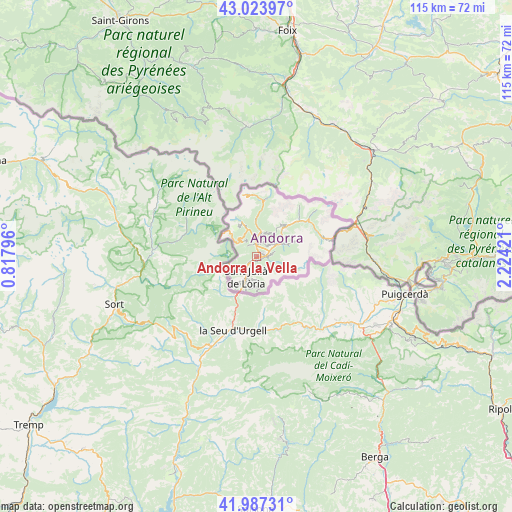
Andorra la Vella GPS coordinates[2]
42° 30' 28.044" North, 1° 31' 15.924" East
| Map corner | latitude | longitude |
|---|---|---|
| Upper-left | 43.02397°, | 0.81796° |
| Center: | 42.50779°, | 1.52109° |
| Lower-right: | 41.98731°, | 2.22421° |
| Map W x H: | 115.3×115.3 km | = 71.6×71.6mi |
| max Lat: | 42.57952° ⇑81.8% North |
| Andorra la Vella: | 42.50779° |
| min Lat: | ⇓18.2% South 42.46372° |
| min Long | Andorra la Vell | max Long |
| 1.48453° | 1.52109° | 1.73361° |
| W 27.3%⇐ | ⇒72.7% E |
Elevation
Elevation of Andorra la Vella is 1037 m = 3402 ft, and this is 360.5 m = 1183 ft below average elevation for this country.
| Max E: |
2106 m = 6909 ft | 81.8% |
| Avg. | 1397.5 m = 4585 ft | |
| Andorra la Vella | 1037 m = 3402 ft | |
Min E: |
921 m = 3022 ft | 18.2% |
See also: Andorra elevation on elevation.city.
Geographical zone
Andorra la Vella is located in North temperate zone (between Tropic of Cancer and the Arctic Circle). Distance of this Northern Tropic circle is 2120.5 km =1317.6 mi to South.| Distance of | km | miles | from Andorra la Vella |
|---|---|---|---|
| North Pole | 5280.6 | 3281.2 | to North |
| Arctic Circle | 2674.8 | 1662 | to North |
| Tropic Cancer | 2120.5 | 1317.6 | to South |
| Equator | 4726.4 | 2936.8 | to South |


Nearby cities:
11 places around Andorra la Vella: (largest is in red/bold)
• Arinsal
7.7 km =4.8 mi,  337°
337°
• Canillo
9.1 km =5.7 mi,  43°
43°
• El Tarter
13.5 km =8.4 mi,  53°
53°
• Encamp
5.7 km =3.5 mi,  58°
58°
• Ordino
5.5 km =3.4 mi,  10°
10°
• Pas de la Casa
17.8 km =11.1 mi,  77°
77°
• Sant Julià de Lòria
5.5 km =3.4 mi,  206°
206°
• Soldeu
14.3 km =8.9 mi, 57°
• l'Aldosa
4 km =2.5 mi,  2°
2°
• la Massana
4.2 km =2.6 mi,  352°
352°
• les Escaldes
1.1 km =0.7 mi,  92°
92°
Sources, notices
• [Note1] Compared only with cities in Andorra existing in our database
• [Src1] Map data: © OpenStreetMap contributors (CC-BY-SA)
• [Src2] Other city data from geonames.org with taken over terms of usage.
• [Src3] Geographical zone / Annual Mean Temperature by Robert A. Rohde @ Wikipedia
