The Valley geodata
The Valley is a capital of a political entity; located in Anguilla in America/Anguilla (GMT-4) time zone. With population of 2,035 people, there are 0 cities with bigger population in this country. Compared to other cities in Anguilla, 61.5% of cities are located further ↓South; 53.8% of cities are located further →East and 61.5% of cities have higher elevation than The Valley. Note1


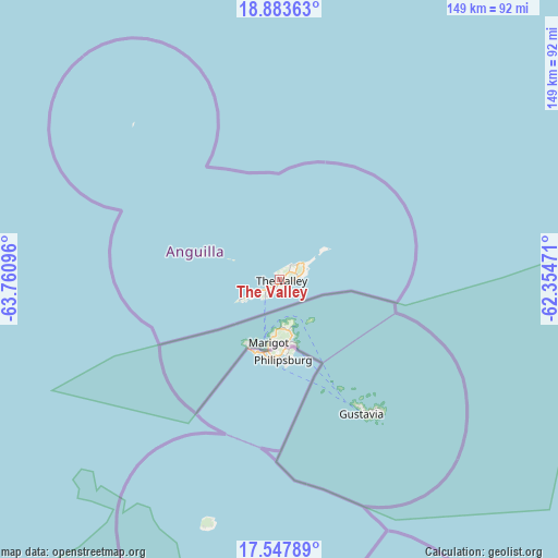
The Valley GPS coordinates[2]
18° 13' 1.344" North, 63° 3' 28.188" West
| Map corner | latitude | longitude |
|---|---|---|
| Upper-left | 18.88363°, | -63.76096° |
| Center: | 18.21704°, | -63.05783° |
| Lower-right: | 17.54789°, | -62.35471° |
| Map W x H: | 148.5×148.5 km | = 92.3×92.3mi |
| max Lat: | 18.25601° ⇑38.5% North |
| The Valley: | 18.21704° |
| min Lat: | ⇓61.5% South 18.17191° |
| min Long | The Valley | max Long |
| -63.14941° | -63.05783° | -63° |
| W 46.2%⇐ | ⇒53.8% E |
Elevation
Elevation of The Valley is 19 m = 62 ft, and this is 3.8 m = 12 ft below average elevation for this country.
| Max E: |
40 m = 131 ft | 61.5% |
| Avg. | 22.8 m = 75 ft | |
| The Valley | 19 m = 62 ft | |
Min E: |
4 m = 13 ft | 38.5% |
See also: Anguilla elevation on elevation.city.
Geographical zone
The Valley is located in North Torrid zone (between Equator and Tropic of Cancer). Distance of this Northern Tropic circle is 580.4 km =360.6 mi to North.| Distance of | km | miles | from The Valley |
|---|---|---|---|
| North Pole | 7981.5 | 4959.5 | to North |
| Arctic Circle | 5375.6 | 3340.2 | to North |
| Tropic Cancer | 580.4 | 360.6 | to North |
| Equator | 2025.5 | 1258.6 | to South |


Nearby cities:
13 places around The Valley: (largest is in red/bold)
• Blowing Point Village
5.9 km =3.7 mi,  220°
220°
• East End Village
6.4 km =4 mi,  73°
73°
• Farrington
3.8 km =2.4 mi,  93°
93°
• George Hill
2.2 km =1.4 mi,  205°
205°
• Island Harbour
6.6 km =4.1 mi,  49°
49°
• North Hill Village
2.5 km =1.6 mi,  239°
239°
• North Side
2 km =1.2 mi, 47°
• Sandy Ground Village
3.8 km =2.4 mi, 242°
• Sandy Hill
4.7 km =2.9 mi,  84°
84°
• South Hill Village
4.2 km =2.6 mi,  228°
228°
• Stoney Ground
1.3 km =0.8 mi, 73°
• The Quarter
2 km =1.2 mi,  120°
120°
• West End Village
10.9 km =6.8 mi, 242°
Sources, notices
• [Note1] Compared only with cities in Anguilla existing in our database
• [Src1] Map data: © OpenStreetMap contributors (CC-BY-SA)
• [Src2] Other city data from geonames.org with taken over terms of usage.
• [Src3] Geographical zone / Annual Mean Temperature by Robert A. Rohde @ Wikipedia
