East End Village geodata
East End Village (East End) is a seat of a first-order administrative division; located in Anguilla in America/Anguilla (GMT-4) time zone. In our database, there are 3 cities with bigger population. Compared to other cities in Anguilla, 92.3% of cities are located further ↓South; 100% of cities are located further ←West and 92.3% of cities have higher elevation than East End Village. Note1


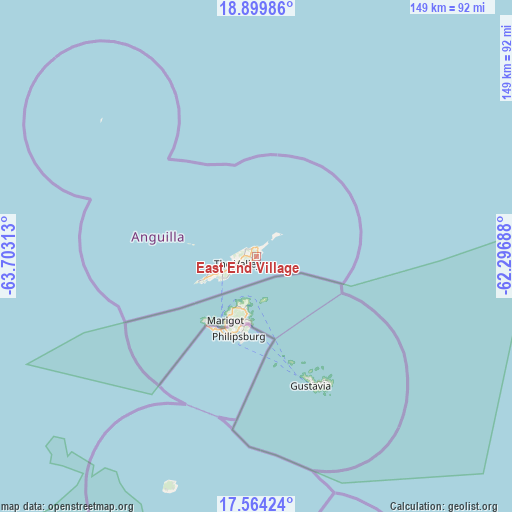
East End Village GPS coordinates[2]
18° 13' 59.988" North, 63° 0' 0" West
| Map corner | latitude | longitude |
|---|---|---|
| Upper-left | 18.89986°, | -63.70313° |
| Center: | 18.23333°, | -63° |
| Lower-right: | 17.56424°, | -62.29688° |
| Map W x H: | 148.5×148.5 km | = 92.3×92.3mi |
| max Lat: | 18.25601° ⇑7.7% North |
| East End Village: | 18.23333° |
| min Lat: | ⇓92.3% South 18.17191° |
| min Long | East End Villag | max Long |
| -63.14941° | -63° | -63° |
| W 100%⇐ | ⇒0% E |
Elevation
Elevation of East End Village is 6 m = 20 ft, and this is 16.8 m = 55 ft below average elevation for this country.
| Max E: |
40 m = 131 ft | 92.3% |
| Avg. | 22.8 m = 75 ft | |
| East End Village | 6 m = 20 ft | |
Min E: |
4 m = 13 ft | 7.7% |
See also: Anguilla elevation on elevation.city.
Geographical zone
East End Village is located in North Torrid zone (between Equator and Tropic of Cancer). Distance of this Northern Tropic circle is 578.6 km =359.5 mi to North.| Distance of | km | miles | from East End Village |
|---|---|---|---|
| North Pole | 7979.7 | 4958.4 | to North |
| Arctic Circle | 5373.8 | 3339.1 | to North |
| Tropic Cancer | 578.6 | 359.5 | to North |
| Equator | 2027.4 | 1259.8 | to South |


Nearby cities:
13 places around East End Village: (largest is in red/bold)
• Blowing Point Village
11.7 km =7.3 mi,  237°
237°
• Farrington
3.1 km =1.9 mi,  229°
229°
• George Hill
8 km =5 mi, 241°
• Island Harbour
2.7 km =1.7 mi,  336°
336°
• North Hill Village
8.8 km =5.5 mi,  249°
249°
• North Side
4.7 km =2.9 mi,  264°
264°
• Sandy Ground Village
10.2 km =6.3 mi, 249°
• Sandy Hill
2 km =1.2 mi, 225°
• South Hill Village
10.3 km =6.4 mi, 243°
• Stoney Ground
5.1 km =3.2 mi, 253°
• The Quarter
5.2 km =3.2 mi, 237°
• The Valley
6.4 km =4 mi, 253°
• West End Village
17.2 km =10.7 mi, 246°
Sources, notices
• [Note1] Compared only with cities in Anguilla existing in our database
• [Src1] Map data: © OpenStreetMap contributors (CC-BY-SA)
• [Src2] Other city data from geonames.org with taken over terms of usage.
• [Src3] Geographical zone / Annual Mean Temperature by Robert A. Rohde @ Wikipedia
