Tirana geodata
Tirana is a capital of a political entity; located in Albania in Europe/Tirane (GMT+2) time zone. With population of 374,801 people, there are 0 cities with bigger population in this country. Compared to other cities in Albania, 63.1% of cities are located further ↓South; 63.7% of cities are located further →East and 66.2% of cities have higher elevation than Tirana. Note1


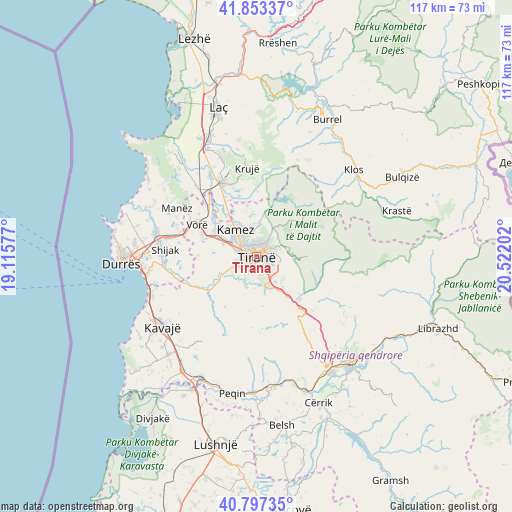
Tirana GPS coordinates[2]
41° 19' 39" North, 19° 49' 8.004" East
| Map corner | latitude | longitude |
|---|---|---|
| Upper-left | 41.85337°, | 19.11577° |
| Center: | 41.3275°, | 19.81889° |
| Lower-right: | 40.79735°, | 20.52202° |
| Map W x H: | 117.4×117.4 km | = 72.9×72.9mi |
| max Lat: | 42.45139° ⇑36.9% North |
| Tirana: | 41.3275° |
| min Lat: | ⇓63.1% South 39.65889° |
| min Long | Tirana | max Long |
| 19.40556° | 19.81889° | 20.99° |
| W 36.3%⇐ | ⇒63.7% E |
Elevation
Elevation of Tirana is 113 m = 371 ft, and this is 261.6 m = 858 ft below average elevation for this country.
| Max E: |
1352 m = 4436 ft | 66.2% |
| Avg. | 374.6 m = 1229 ft | |
| Tirana | 113 m = 371 ft | |
Min E: |
-2 m = -7 ft | 33.8% |
See also: Tirana elevation on elevation.city.
Geographical zone
Tirana is located in North temperate zone (between Tropic of Cancer and the Arctic Circle). Distance of this Northern Tropic circle is 1989.3 km =1236.1 mi to South.| Distance of | km | miles | from Tirana |
|---|---|---|---|
| North Pole | 5411.9 | 3362.8 | to North |
| Arctic Circle | 2806 | 1743.6 | to North |
| Tropic Cancer | 1989.3 | 1236.1 | to South |
| Equator | 4595.2 | 2855.3 | to South |


Nearby cities:
15 places around Tirana: (largest is in red/bold)
• Baldushk
12.8 km =8 mi,  188°
188°
• Bërxull
12.4 km =7.7 mi,  298°
298°
• Bërzhitë
11.4 km =7.1 mi,  143°
143°
• Dajt
10.9 km =6.8 mi,  47°
47°
• Farka e Madhe
4.7 km =2.9 mi,  121°
121°
• Kallmet
10.1 km =6.3 mi,  1°
1°
• Kamëz
7.8 km =4.8 mi,  320°
320°
• Kashar
9.4 km =5.8 mi,  285°
285°
• Ndroq
15.3 km =9.5 mi,  242°
242°
• Nikël
14.2 km =8.8 mi,  335°
335°
• Paskuqan
3.1 km =1.9 mi, 340°
• Petrelë
8.8 km =5.5 mi,  160°
160°
• Vaqarr
7 km =4.3 mi, 243°
• Zall-Bastar
14.7 km =9.1 mi,  39°
39°
• Zall-Herr
6.9 km =4.3 mi,  5°
5°
Sources, notices
• [Note1] Compared only with cities in Albania existing in our database
• [Src1] Map data: © OpenStreetMap contributors (CC-BY-SA)
• [Src2] Other city data from geonames.org with taken over terms of usage.
• [Src3] Geographical zone / Annual Mean Temperature by Robert A. Rohde @ Wikipedia
