Kashar geodata
Kashar (Tirana) is a seat of a third-order administrative division; located in Albania in Europe/Tirane (GMT+2) time zone. In our database, there are 71 cities with bigger population. Compared to other cities in Albania, 64.5% of cities are located further ↓South; 74.9% of cities are located further →East and 56.9% of cities have higher elevation than Kashar. Note1


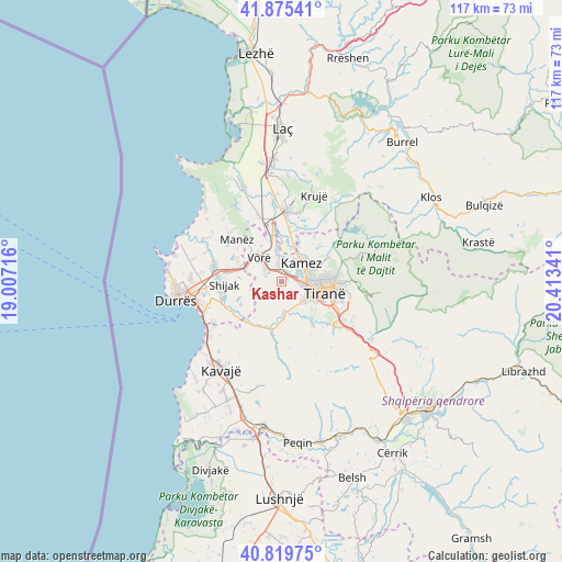
Kashar GPS coordinates[2]
41° 20' 58.992" North, 19° 42' 37.008" East
| Map corner | latitude | longitude |
|---|---|---|
| Upper-left | 41.87541°, | 19.00716° |
| Center: | 41.34972°, | 19.71028° |
| Lower-right: | 40.81975°, | 20.41341° |
| Map W x H: | 117.4×117.4 km | = 72.9×72.9mi |
| max Lat: | 42.45139° ⇑35.5% North |
| Kashar: | 41.34972° |
| min Lat: | ⇓64.5% South 39.65889° |
| min Long | Kashar | max Long |
| 19.40556° | 19.71028° | 20.99° |
| W 25.1%⇐ | ⇒74.9% E |
Elevation
Elevation of Kashar is 202 m = 663 ft, and this is 172.6 m = 566 ft below average elevation for this country.
| Max E: |
1352 m = 4436 ft | 56.9% |
| Avg. | 374.6 m = 1229 ft | |
| Kashar | 202 m = 663 ft | |
Min E: |
-2 m = -7 ft | 43.1% |
See also: Albania elevation on elevation.city.
Geographical zone
Kashar is located in North temperate zone (between Tropic of Cancer and the Arctic Circle). Distance of this Northern Tropic circle is 1991.7 km =1237.6 mi to South.| Distance of | km | miles | from Kashar |
|---|---|---|---|
| North Pole | 5409.4 | 3361.2 | to North |
| Arctic Circle | 2803.5 | 1742 | to North |
| Tropic Cancer | 1991.7 | 1237.6 | to South |
| Equator | 4597.7 | 2856.9 | to South |


Nearby cities:
15 places around Kashar: (largest is in red/bold)
• Bërxull
3.9 km =2.4 mi,  330°
330°
• Gjepalaj
11.2 km =7 mi,  260°
260°
• Kallmet
12 km =7.5 mi,  50°
50°
• Kamëz
5.5 km =3.4 mi, 49°
• Maminas
9.2 km =5.7 mi,  290°
290°
• Manzë
13.1 km =8.1 mi,  311°
311°
• Ndroq
10.6 km =6.6 mi,  205°
205°
• Nikël
11 km =6.8 mi,  16°
16°
• Paskuqan
8.1 km =5 mi,  86°
86°
• Prezë
9.2 km =5.7 mi,  340°
340°
• Shijak
12 km =7.5 mi,  267°
267°
• Tirana
9.4 km =5.8 mi,  105°
105°
• Vaqarr
6.3 km =3.9 mi,  153°
153°
• Vorë
6.5 km =4 mi, 314°
• Zall-Herr
10.7 km =6.6 mi,  65°
65°
Sources, notices
• [Note1] Compared only with cities in Albania existing in our database
• [Src1] Map data: © OpenStreetMap contributors (CC-BY-SA)
• [Src2] Other city data from geonames.org with taken over terms of usage.
• [Src3] Geographical zone / Annual Mean Temperature by Robert A. Rohde @ Wikipedia
