Petrelë geodata
Petrelë (Tirana) is a seat of a third-order administrative division; located in Albania in Europe/Tirane (GMT+2) time zone. In our database, there are 71 cities with bigger population. Compared to other cities in Albania, 60.8% of cities are located further ↓South; 60.3% of cities are located further →East and 51.5% of cities have lower elevation than Petrelë. Note1


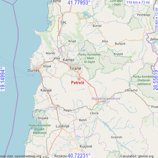
Petrelë GPS coordinates[2]
41° 15' 11.016" North, 19° 51' 11.016" East
| Map corner | latitude | longitude |
|---|---|---|
| Upper-left | 41.77953°, | 19.14994° |
| Center: | 41.25306°, | 19.85306° |
| Lower-right: | 40.72231°, | 20.55619° |
| Map W x H: | 117.6×117.6 km | = 73.1×73.1mi |
| max Lat: | 42.45139° ⇑39.2% North |
| Petrelë: | 41.25306° |
| min Lat: | ⇓60.8% South 39.65889° |
| min Long | Petrelë | max Long |
| 19.40556° | 19.85306° | 20.99° |
| W 39.7%⇐ | ⇒60.3% E |
Elevation
Elevation of Petrelë is 298 m = 978 ft, and this is 76.6 m = 251 ft below average elevation for this country.
| Max E: |
1352 m = 4436 ft | 48.5% |
| Avg. | 374.6 m = 1229 ft | |
| Petrelë | 298 m = 978 ft | |
Min E: |
-2 m = -7 ft | 51.5% |
See also: Albania elevation on elevation.city.
Geographical zone
Petrelë is located in North temperate zone (between Tropic of Cancer and the Arctic Circle). Distance of this Northern Tropic circle is 1981 km =1230.9 mi to South.| Distance of | km | miles | from Petrelë |
|---|---|---|---|
| North Pole | 5420.2 | 3368 | to North |
| Arctic Circle | 2814.3 | 1748.7 | to North |
| Tropic Cancer | 1981 | 1230.9 | to South |
| Equator | 4586.9 | 2850.2 | to South |


Nearby cities:
15 places around Petrelë: (largest is in red/bold)
• Baldushk
6.4 km =4 mi,  227°
227°
• Bërzhitë
4.1 km =2.5 mi,  102°
102°
• Dajt
16.5 km =10.3 mi,  18°
18°
• Farka e Madhe
6 km =3.7 mi,  11°
11°
• Funarë
18.4 km =11.4 mi,  110°
110°
• Gracen
14.6 km =9.1 mi,  140°
140°
• Kamëz
16.3 km =10.1 mi,  331°
331°
• Kashar
16.1 km =10 mi,  312°
312°
• Krrabë
10.7 km =6.6 mi, 112°
• Ndroq
16.5 km =10.3 mi,  274°
274°
• Paskuqan
11.9 km =7.4 mi,  340°
340°
• Peza e Madhe
13.7 km =8.5 mi,  253°
253°
• Tirana
8.8 km =5.5 mi, 340°
• Vaqarr
10.4 km =6.5 mi,  299°
299°
• Zall-Herr
15.3 km =9.5 mi,  351°
351°
Sources, notices
• [Note1] Compared only with cities in Albania existing in our database
• [Src1] Map data: © OpenStreetMap contributors (CC-BY-SA)
• [Src2] Other city data from geonames.org with taken over terms of usage.
• [Src3] Geographical zone / Annual Mean Temperature by Robert A. Rohde @ Wikipedia
