Portëz geodata
Portëz (Fier) is a seat of a third-order administrative division; located in Albania in Europe/Tirane (GMT+2) time zone. In our database, there are 71 cities with bigger population. Compared to other cities in Albania, 73% of cities are located further ↑North; 90.1% of cities are located further →East and 74.4% of cities have higher elevation than Portëz. Note1


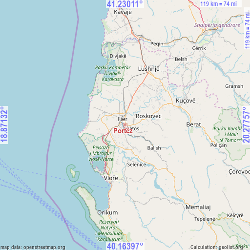
Portëz GPS coordinates[2]
40° 41' 57.012" North, 19° 34' 27.984" East
| Map corner | latitude | longitude |
|---|---|---|
| Upper-left | 41.23011°, | 18.87132° |
| Center: | 40.69917°, | 19.57444° |
| Lower-right: | 40.16397°, | 20.27757° |
| Map W x H: | 118.5×118.5 km | = 73.6×73.6mi |
| max Lat: | 42.45139° ⇑73% North |
| Portëz: | 40.69917° |
| min Lat: | ⇓27% South 39.65889° |
| min Long | Portëz | max Long |
| 19.40556° | 19.57444° | 20.99° |
| W 9.9%⇐ | ⇒90.1% E |
Elevation
Elevation of Portëz is 58 m = 190 ft, and this is 316.6 m = 1039 ft below average elevation for this country.
| Max E: |
1352 m = 4436 ft | 74.4% |
| Avg. | 374.6 m = 1229 ft | |
| Portëz | 58 m = 190 ft | |
Min E: |
-2 m = -7 ft | 25.6% |
See also: Albania elevation on elevation.city.
Geographical zone
Portëz is located in North temperate zone (between Tropic of Cancer and the Arctic Circle). Distance of this Northern Tropic circle is 1919.4 km =1192.7 mi to South.| Distance of | km | miles | from Portëz |
|---|---|---|---|
| North Pole | 5481.7 | 3406.2 | to North |
| Arctic Circle | 2875.9 | 1787 | to North |
| Tropic Cancer | 1919.4 | 1192.7 | to South |
| Equator | 4525.3 | 2811.9 | to South |


Nearby cities:
15 places around Portëz: (largest is in red/bold)
• Cakran
11.5 km =7.1 mi,  157°
157°
• Dërmënas
8.5 km =5.3 mi,  307°
307°
• Fier
3.2 km =2 mi,  330°
330°
• Fier-Çifçi
2.1 km =1.3 mi,  341°
341°
• Frakulla e Madhe
7.7 km =4.8 mi,  231°
231°
• Kuman
9.9 km =6.2 mi,  72°
72°
• Levan
7.6 km =4.7 mi,  250°
250°
• Mbrostar-Urë
6.1 km =3.8 mi,  3°
3°
• Novoselë
12.3 km =7.6 mi, 227°
• Patos
4.2 km =2.6 mi,  114°
114°
• Patos Fshat
9 km =5.6 mi,  134°
134°
• Roskovec
11.6 km =7.2 mi, 68°
• Ruzhdie
10.9 km =6.8 mi, 106°
• Topojë
13.9 km =8.6 mi,  300°
300°
• Zharrëz
6.4 km =4 mi,  80°
80°
Sources, notices
• [Note1] Compared only with cities in Albania existing in our database
• [Src1] Map data: © OpenStreetMap contributors (CC-BY-SA)
• [Src2] Other city data from geonames.org with taken over terms of usage.
• [Src3] Geographical zone / Annual Mean Temperature by Robert A. Rohde @ Wikipedia
