Novoselë geodata
Novoselë (Vlorë) is a seat of a third-order administrative division; located in Albania in Europe/Tirane (GMT+2) time zone. In our database, there are 71 cities with bigger population. Compared to other cities in Albania, 77.2% of cities are located further ↑North; 98.3% of cities are located further →East and 97.7% of cities have higher elevation than Novoselë. Note1


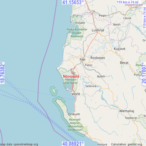
Novoselë GPS coordinates[2]
40° 37' 30" North, 19° 28' 0.984" East
| Map corner | latitude | longitude |
|---|---|---|
| Upper-left | 41.15653°, | 18.76382° |
| Center: | 40.625°, | 19.46694° |
| Lower-right: | 40.08921°, | 20.17007° |
| Map W x H: | 118.7×118.7 km | = 73.8×73.8mi |
| max Lat: | 42.45139° ⇑77.2% North |
| Novoselë: | 40.625° |
| min Lat: | ⇓22.8% South 39.65889° |
| min Long | Novoselë | max Long |
| 19.40556° | 19.46694° | 20.99° |
| W 1.7%⇐ | ⇒98.3% E |
Elevation
Elevation of Novoselë is 6 m = 20 ft, and this is 368.6 m = 1209 ft below average elevation for this country.
| Max E: |
1352 m = 4436 ft | 97.7% |
| Avg. | 374.6 m = 1229 ft | |
| Novoselë | 6 m = 20 ft | |
Min E: |
-2 m = -7 ft | 2.3% |
See also: Albania elevation on elevation.city.
Geographical zone
Novoselë is located in North temperate zone (between Tropic of Cancer and the Arctic Circle). Distance of this Northern Tropic circle is 1911.2 km =1187.6 mi to South.| Distance of | km | miles | from Novoselë |
|---|---|---|---|
| North Pole | 5490 | 3411.3 | to North |
| Arctic Circle | 2884.1 | 1792.1 | to North |
| Tropic Cancer | 1911.2 | 1187.6 | to South |
| Equator | 4517.1 | 2806.8 | to South |


Nearby cities:
15 places around Novoselë: (largest is in red/bold)
• Armen
14.7 km =9.1 mi,  132°
132°
• Cakran
13.6 km =8.5 mi,  100°
100°
• Dërmënas
13.6 km =8.5 mi,  9°
9°
• Fier
13.3 km =8.3 mi,  34°
34°
• Fier-Çifçi
13.2 km =8.2 mi,  39°
39°
• Frakulla e Madhe
4.6 km =2.9 mi, 41°
• Levan
6 km =3.7 mi,  18°
18°
• Mbrostar-Urë
17.2 km =10.7 mi, 33°
• Patos
14.4 km =8.9 mi,  63°
63°
• Patos Fshat
15.6 km =9.7 mi,  82°
82°
• Portëz
12.3 km =7.6 mi,  47°
47°
• Selenicë
17.7 km =11 mi, 126°
• Topojë
15.6 km =9.7 mi,  349°
349°
• Vlorë
17.4 km =10.8 mi,  175°
175°
• Zharrëz
18 km =11.2 mi, 58°
Sources, notices
• [Note1] Compared only with cities in Albania existing in our database
• [Src1] Map data: © OpenStreetMap contributors (CC-BY-SA)
• [Src2] Other city data from geonames.org with taken over terms of usage.
• [Src3] Geographical zone / Annual Mean Temperature by Robert A. Rohde @ Wikipedia
