Kolonjë geodata
Kolonjë (Fier) is a seat of a third-order administrative division; located in Albania in Europe/Tirane (GMT+2) time zone. In our database, there are 71 cities with bigger population. Compared to other cities in Albania, 63.1% of cities are located further ↑North; 87% of cities are located further →East and 81.7% of cities have higher elevation than Kolonjë. Note1


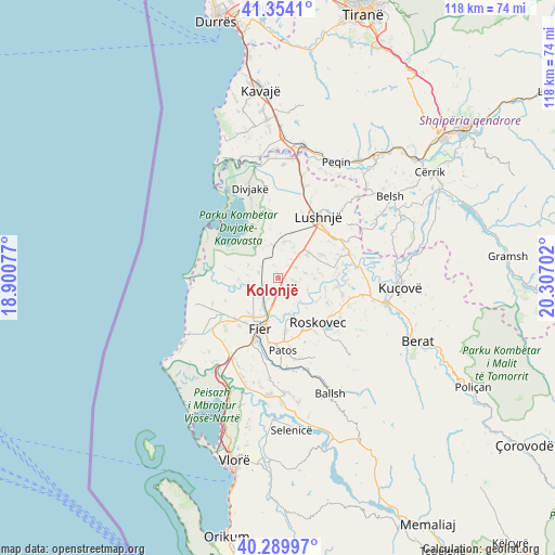
Kolonjë GPS coordinates[2]
40° 49' 27.012" North, 19° 36' 14.004" East
| Map corner | latitude | longitude |
|---|---|---|
| Upper-left | 41.3541°, | 18.90077° |
| Center: | 40.82417°, | 19.60389° |
| Lower-right: | 40.28997°, | 20.30702° |
| Map W x H: | 118.3×118.3 km | = 73.5×73.5mi |
| max Lat: | 42.45139° ⇑63.1% North |
| Kolonjë: | 40.82417° |
| min Lat: | ⇓36.9% South 39.65889° |
| min Long | Kolonjë | max Long |
| 19.40556° | 19.60389° | 20.99° |
| W 13%⇐ | ⇒87% E |
Elevation
Elevation of Kolonjë is 33 m = 108 ft, and this is 341.6 m = 1121 ft below average elevation for this country.
| Max E: |
1352 m = 4436 ft | 81.7% |
| Avg. | 374.6 m = 1229 ft | |
| Kolonjë | 33 m = 108 ft | |
Min E: |
-2 m = -7 ft | 18.3% |
See also: Albania elevation on elevation.city.
Geographical zone
Kolonjë is located in North temperate zone (between Tropic of Cancer and the Arctic Circle). Distance of this Northern Tropic circle is 1933.3 km =1201.3 mi to South.| Distance of | km | miles | from Kolonjë |
|---|---|---|---|
| North Pole | 5467.8 | 3397.5 | to North |
| Arctic Circle | 2862 | 1778.4 | to North |
| Tropic Cancer | 1933.3 | 1201.3 | to South |
| Equator | 4539.2 | 2820.5 | to South |


Nearby cities:
15 places around Kolonjë: (largest is in red/bold)
• Allkaj
13.3 km =8.3 mi,  73°
73°
• Bubullimë
3.2 km =2 mi,  102°
102°
• Dërmënas
12.7 km =7.9 mi,  226°
226°
• Fier
11.9 km =7.4 mi,  199°
199°
• Fier-Çifçi
12.4 km =7.7 mi,  194°
194°
• Gradishtë
7.3 km =4.5 mi,  347°
347°
• Krutja e Poshtme
8.4 km =5.2 mi,  50°
50°
• Kuman
12.9 km =8 mi,  147°
147°
• Libofshë
4.5 km =2.8 mi,  284°
284°
• Mbrostar-Urë
8.1 km =5 mi, 194°
• Portëz
14.1 km =8.8 mi, 190°
• Remas
10.4 km =6.5 mi,  311°
311°
• Roskovec
12.7 km =7.9 mi,  139°
139°
• Strum
13.9 km =8.6 mi,  125°
125°
• Zharrëz
13.4 km =8.3 mi,  163°
163°
Sources, notices
• [Note1] Compared only with cities in Albania existing in our database
• [Src1] Map data: © OpenStreetMap contributors (CC-BY-SA)
• [Src2] Other city data from geonames.org with taken over terms of usage.
• [Src3] Geographical zone / Annual Mean Temperature by Robert A. Rohde @ Wikipedia
