Strum geodata
Strum (Fier) is a seat of a third-order administrative division; located in Albania in Europe/Tirane (GMT+2) time zone. In our database, there are 71 cities with bigger population. Compared to other cities in Albania, 67.9% of cities are located further ↑North; 72.1% of cities are located further →East and 79.2% of cities have higher elevation than Strum. Note1


Strum GPS coordinates[2]
40° 45' 3.996" North, 19° 44' 15" East
| Map corner | latitude | longitude |
|---|---|---|
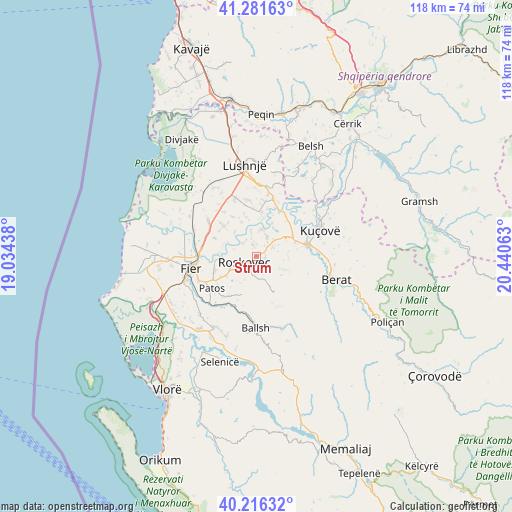
| Upper-left | 41.28163°, | 19.03438° |
| Center: | 40.75111°, | 19.7375° |
| Lower-right: | 40.21632°, | 20.44063° |
| Map W x H: | 118.5×118.4 km | = 73.6×73.6mi |
| max Lat: | 42.45139° ⇑67.9% North |
| Strum: | 40.75111° |
| min Lat: | ⇓32.1% South 39.65889° |
| min Long | Strum | max Long |
| 19.40556° | 19.7375° | 20.99° |
| W 27.9%⇐ | ⇒72.1% E |
Elevation
Elevation of Strum is 35 m = 115 ft, and this is 339.6 m = 1114 ft below average elevation for this country.
| Max E: |
1352 m = 4436 ft | 79.2% |
| Avg. | 374.6 m = 1229 ft | |
| Strum | 35 m = 115 ft | |
Min E: |
-2 m = -7 ft | 20.8% |
See also: Albania elevation on elevation.city.
Geographical zone
Strum is located in North temperate zone (between Tropic of Cancer and the Arctic Circle). Distance of this Northern Tropic circle is 1925.2 km =1196.3 mi to South.| Distance of | km | miles | from Strum |
|---|---|---|---|
| North Pole | 5476 | 3402.6 | to North |
| Arctic Circle | 2870.1 | 1783.4 | to North |
| Tropic Cancer | 1925.2 | 1196.3 | to South |
| Equator | 4531.1 | 2815.5 | to South |


Nearby cities:
15 places around Strum: (largest is in red/bold)
• Allkaj
11.9 km =7.4 mi,  7°
7°
• Banaj
12 km =7.5 mi,  46°
46°
• Bubullimë
11 km =6.8 mi,  312°
312°
• Cukalat
5 km =3.1 mi,  117°
117°
• Dushk
3.2 km =2 mi,  148°
148°
• Kuman
5.1 km =3.2 mi,  237°
237°
• Kurjan
3.8 km =2.4 mi,  169°
169°
• Kutalli
5.5 km =3.4 mi, 48°
• Ngraçan
12.7 km =7.9 mi,  158°
158°
• Patos
12.5 km =7.8 mi,  232°
232°
• Poshnje
9.6 km =6 mi,  70°
70°
• Roskovec
3.3 km =2.1 mi, 243°
• Ruzhdie
9.5 km =5.9 mi,  200°
200°
• Ura Vajgurore
12 km =7.5 mi,  80°
80°
• Zharrëz
8.7 km =5.4 mi, 237°
Sources, notices
• [Note1] Compared only with cities in Albania existing in our database
• [Src1] Map data: © OpenStreetMap contributors (CC-BY-SA)
• [Src2] Other city data from geonames.org with taken over terms of usage.
• [Src3] Geographical zone / Annual Mean Temperature by Robert A. Rohde @ Wikipedia
