Dhivër geodata
Dhivër (Vlorë) is a seat of a third-order administrative division; located in Albania in Europe/Tirane (GMT+2) time zone. In our database, there are 71 cities with bigger population. Compared to other cities in Albania, 98.6% of cities are located further ↑North; 65.9% of cities are located further ←West and 58.9% of cities have lower elevation than Dhivër. Note1


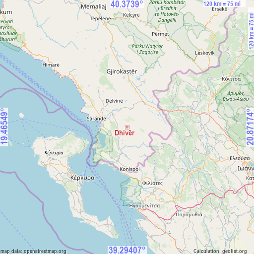
Dhivër GPS coordinates[2]
39° 50' 9.996" North, 20° 10' 6.996" East
| Map corner | latitude | longitude |
|---|---|---|
| Upper-left | 40.3739°, | 19.46549° |
| Center: | 39.83611°, | 20.16861° |
| Lower-right: | 39.29407°, | 20.87174° |
| Map W x H: | 120.1×120.1 km | = 74.6×74.6mi |
| max Lat: | 42.45139° ⇑98.6% North |
| Dhivër: | 39.83611° |
| min Lat: | ⇓1.4% South 39.65889° |
| min Long | Dhivër | max Long |
| 19.40556° | 20.16861° | 20.99° |
| W 65.9%⇐ | ⇒34.1% E |
Elevation
Elevation of Dhivër is 382 m = 1253 ft, and this is 7.4 m = 24 ft above average elevation for this country.
| Max E: |
1352 m = 4436 ft | 41.1% |
| Dhivër | 382 m 1253 ft | |
| Avg. | 374.6 m = 1229 ft | |
Min E: |
-2 m = -7 ft | 58.9% |
See also: Albania elevation on elevation.city.
Geographical zone
Dhivër is located in North temperate zone (between Tropic of Cancer and the Arctic Circle). Distance of this Northern Tropic circle is 1823.4 km =1133 mi to South.| Distance of | km | miles | from Dhivër |
|---|---|---|---|
| North Pole | 5577.7 | 3465.8 | to North |
| Arctic Circle | 2971.8 | 1846.6 | to North |
| Tropic Cancer | 1823.4 | 1133 | to South |
| Equator | 4429.4 | 2752.3 | to South |


Nearby cities:
15 places around Dhivër: (largest is in red/bold)
• Aliko
8 km =5 mi,  288°
288°
• Delvinë
14.1 km =8.8 mi,  334°
334°
• Finiq
12.2 km =7.6 mi,  309°
309°
• Gjirokastër
26.8 km =16.7 mi,  354°
354°
• Kakavijë
18 km =11.2 mi,  63°
63°
• Konispol
19.7 km =12.2 mi,  176°
176°
• Ksamil
16.2 km =10.1 mi,  242°
242°
• Lazarat
23.5 km =14.6 mi,  355°
355°
• Libohovë
23.1 km =14.4 mi,  20°
20°
• Livadhja
6.6 km =4.1 mi,  217°
217°
• Markat
11.7 km =7.3 mi,  168°
168°
• Mesopotam
10.5 km =6.5 mi,  321°
321°
• Sarandë
14.6 km =9.1 mi, 287°
• Vergo
23.3 km =14.5 mi, 324°
• Xarrë
15.5 km =9.6 mi, 219°
Sources, notices
• [Note1] Compared only with cities in Albania existing in our database
• [Src1] Map data: © OpenStreetMap contributors (CC-BY-SA)
• [Src2] Other city data from geonames.org with taken over terms of usage.
• [Src3] Geographical zone / Annual Mean Temperature by Robert A. Rohde @ Wikipedia
