Sarandë geodata
Sarandë (Vlorë) is a seat of a second-order administrative division; located in Albania in Europe/Tirane (GMT+2) time zone. With population of 15,147 people, there are 21 cities with bigger population in this country. Compared to other cities in Albania, 98% of cities are located further ↑North; 51.5% of cities are located further ←West and 60% of cities have higher elevation than Sarandë. Note1


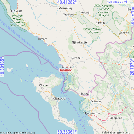
Sarandë GPS coordinates[2]
39° 52' 31.224" North, 20° 0' 17.172" East
| Map corner | latitude | longitude |
|---|---|---|
| Upper-left | 40.41282°, | 19.30165° |
| Center: | 39.87534°, | 20.00477° |
| Lower-right: | 39.33361°, | 20.7079° |
| Map W x H: | 120×120 km | = 74.6×74.6mi |
| max Lat: | 42.45139° ⇑98% North |
| Sarandë: | 39.87534° |
| min Lat: | ⇓2% South 39.65889° |
| min Long | Sarandë | max Long |
| 19.40556° | 20.00477° | 20.99° |
| W 51.5%⇐ | ⇒48.5% E |
Elevation
Elevation of Sarandë is 170 m = 558 ft, and this is 204.6 m = 671 ft below average elevation for this country.
| Max E: |
1352 m = 4436 ft | 60% |
| Avg. | 374.6 m = 1229 ft | |
| Sarandë | 170 m = 558 ft | |
Min E: |
-2 m = -7 ft | 40% |
See also: Albania elevation on elevation.city.
Geographical zone
Sarandë is located in North temperate zone (between Tropic of Cancer and the Arctic Circle). Distance of this Northern Tropic circle is 1827.8 km =1135.7 mi to South.| Distance of | km | miles | from Sarandë |
|---|---|---|---|
| North Pole | 5573.3 | 3463.1 | to North |
| Arctic Circle | 2967.5 | 1843.9 | to North |
| Tropic Cancer | 1827.8 | 1135.7 | to South |
| Equator | 4433.7 | 2755 | to South |


Nearby cities:
15 places around Sarandë: (largest is in red/bold)
• Aliko
6.6 km =4.1 mi,  106°
106°
• Delvinë
11.6 km =7.2 mi,  43°
43°
• Dhivër
14.6 km =9.1 mi, 107°
• Finiq
5.7 km =3.5 mi,  52°
52°
• Gjirokastër
25.1 km =15.6 mi,  27°
27°
• Kardhiq
27.5 km =17.1 mi,  4°
4°
• Ksamil
11.8 km =7.3 mi,  182°
182°
• Lazarat
22.6 km =14 mi, 32°
• Libohovë
28 km =17.4 mi, 51°
• Livadhja
13.9 km =8.6 mi,  133°
133°
• Lukovë
15.1 km =9.4 mi,  329°
329°
• Markat
22.7 km =14.1 mi, 134°
• Mesopotam
8.4 km =5.2 mi,  62°
62°
• Vergo
14.6 km =9.1 mi, 1°
• Xarrë
16.9 km =10.5 mi,  165°
165°
In other languages:
- In German: Saranda
- In Italian: Santi Quaranta
- In Russian: Саранда
- In Chinese: 萨兰达
Sources, notices
• [Note1] Compared only with cities in Albania existing in our database
• [Src1] Map data: © OpenStreetMap contributors (CC-BY-SA)
• [Src2] Other city data from geonames.org with taken over terms of usage.
• [Src3] Geographical zone / Annual Mean Temperature by Robert A. Rohde @ Wikipedia
