Cerava geodata
Cerava (Korçë) is a seat of a third-order administrative division; located in Albania in Europe/Tirane (GMT+2) time zone. In our database, there are 71 cities with bigger population. Compared to other cities in Albania, 61.4% of cities are located further ↑North; 96.6% of cities are located further ←West and 85.1% of cities have lower elevation than Cerava. Note1


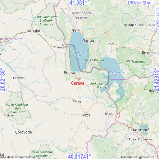
Cerava GPS coordinates[2]
40° 51' 5.004" North, 20° 43' 30" East
| Map corner | latitude | longitude |
|---|---|---|
| Upper-left | 41.3811°, | 20.02188° |
| Center: | 40.85139°, | 20.725° |
| Lower-right: | 40.31741°, | 21.42813° |
| Map W x H: | 118.3×118.3 km | = 73.5×73.5mi |
| max Lat: | 42.45139° ⇑61.4% North |
| Cerava: | 40.85139° |
| min Lat: | ⇓38.6% South 39.65889° |
| min Long | Cerava | max Long |
| 19.40556° | 20.725° | 20.99° |
| W 96.6%⇐ | ⇒3.4% E |
Elevation
Elevation of Cerava is 805 m = 2641 ft, and this is 430.4 m = 1412 ft above average elevation for this country.
| Max E: |
1352 m = 4436 ft | 14.9% |
| Cerava | 805 m 2641 ft | |
| Avg. | 374.6 m = 1229 ft | |
Min E: |
-2 m = -7 ft | 85.1% |
See also: Albania elevation on elevation.city.
Geographical zone
Cerava is located in North temperate zone (between Tropic of Cancer and the Arctic Circle). Distance of this Northern Tropic circle is 1936.3 km =1203.2 mi to South.| Distance of | km | miles | from Cerava |
|---|---|---|---|
| North Pole | 5464.8 | 3395.7 | to North |
| Arctic Circle | 2858.9 | 1776.4 | to North |
| Tropic Cancer | 1936.3 | 1203.2 | to South |
| Equator | 4542.2 | 2822.4 | to South |


Nearby cities:
15 places around Cerava: (largest is in red/bold)
• Buçimas
5.8 km =3.6 mi,  320°
320°
• Dardhas
5.7 km =3.5 mi,  263°
263°
• Dishnicë
23.5 km =14.6 mi,  161°
161°
• Libonik
16.4 km =10.2 mi,  184°
184°
• Liqenas
16.6 km =10.3 mi,  115°
115°
• Maliq
16.3 km =10.1 mi,  187°
187°
• Novoselë
10.3 km =6.4 mi, 192°
• Pirg
7.6 km =4.7 mi, 192°
• Pogradec
8.3 km =5.2 mi,  312°
312°
• Pojan
16.9 km =10.5 mi,  145°
145°
• Proptisht
24 km =14.9 mi, 308°
• Trebinjë
16 km =9.9 mi,  295°
295°
• Udënisht
14.4 km =8.9 mi,  329°
329°
• Velçan
24.9 km =15.5 mi, 297°
• Vreshtas
7.5 km =4.7 mi,  144°
144°
Sources, notices
• [Note1] Compared only with cities in Albania existing in our database
• [Src1] Map data: © OpenStreetMap contributors (CC-BY-SA)
• [Src2] Other city data from geonames.org with taken over terms of usage.
• [Src3] Geographical zone / Annual Mean Temperature by Robert A. Rohde @ Wikipedia
