Martanesh geodata
Martanesh (Dibër) is a seat of a third-order administrative division; located in Albania in Europe/Tirane (GMT+2) time zone. In our database, there are 71 cities with bigger population. Compared to other cities in Albania, 67% of cities are located further ↓South; 69% of cities are located further ←West and 91% of cities have lower elevation than Martanesh. Note1


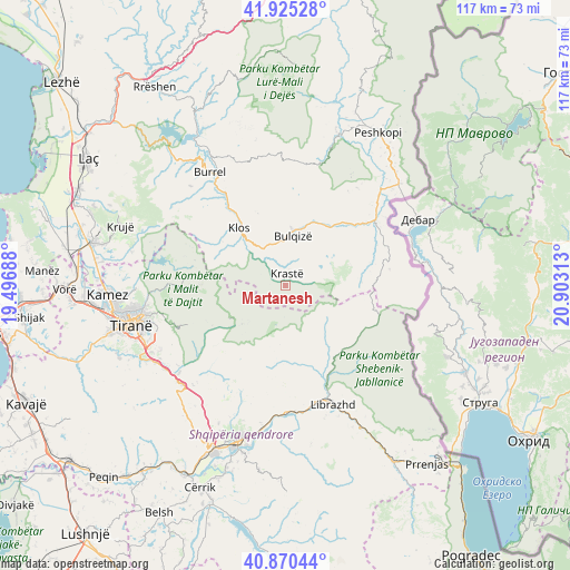
Martanesh GPS coordinates[2]
41° 24' 0" North, 20° 12' 0" East
| Map corner | latitude | longitude |
|---|---|---|
| Upper-left | 41.92528°, | 19.49688° |
| Center: | 41.4°, | 20.2° |
| Lower-right: | 40.87044°, | 20.90313° |
| Map W x H: | 117.3×117.3 km | = 72.9×72.9mi |
| max Lat: | 42.45139° ⇑33% North |
| Martanesh: | 41.4° |
| min Lat: | ⇓67% South 39.65889° |
| min Long | Martanesh | max Long |
| 19.40556° | 20.2° | 20.99° |
| W 69%⇐ | ⇒31% E |
Elevation
Elevation of Martanesh is 905 m = 2969 ft, and this is 530.4 m = 1740 ft above average elevation for this country.
| Max E: |
1352 m = 4436 ft | 9% |
| Martanesh | 905 m 2969 ft | |
| Avg. | 374.6 m = 1229 ft | |
Min E: |
-2 m = -7 ft | 91% |
See also: Albania elevation on elevation.city.
Geographical zone
Martanesh is located in North temperate zone (between Tropic of Cancer and the Arctic Circle). Distance of this Northern Tropic circle is 1997.3 km =1241.1 mi to South.| Distance of | km | miles | from Martanesh |
|---|---|---|---|
| North Pole | 5403.8 | 3357.8 | to North |
| Arctic Circle | 2797.9 | 1738.5 | to North |
| Tropic Cancer | 1997.3 | 1241.1 | to South |
| Equator | 4603.2 | 2860.3 | to South |


Nearby cities:
15 places around Martanesh: (largest is in red/bold)
• Bulqizë
10.4 km =6.5 mi,  10°
10°
• Dajt
23.7 km =14.7 mi,  268°
268°
• Fushë-Bulqizë
15.2 km =9.4 mi,  26°
26°
• Gurra e Vogël
23.1 km =14.4 mi,  310°
310°
• Klos
15.2 km =9.4 mi,  321°
321°
• Labinot-Mal
22.5 km =14 mi,  190°
190°
• Lunik
16.1 km =10 mi,  140°
140°
• Orenjë
12.9 km =8 mi,  175°
175°
• Ostreni i Math
21.6 km =13.4 mi,  80°
80°
• Shupenzë
23.6 km =14.7 mi,  52°
52°
• Steblevë
23.6 km =14.7 mi,  107°
107°
• Suç
23.2 km =14.4 mi,  327°
327°
• Xibër-Murrizë
15.8 km =9.8 mi,  292°
292°
• Zall-Bastar
22.7 km =14.1 mi,  278°
278°
• Zerqan
17.6 km =10.9 mi, 49°
Sources, notices
• [Note1] Compared only with cities in Albania existing in our database
• [Src1] Map data: © OpenStreetMap contributors (CC-BY-SA)
• [Src2] Other city data from geonames.org with taken over terms of usage.
• [Src3] Geographical zone / Annual Mean Temperature by Robert A. Rohde @ Wikipedia
