Fajzë geodata
Fajzë (Kukës) is a seat of a third-order administrative division; located in Albania in Europe/Tirane (GMT+2) time zone. In our database, there are 71 cities with bigger population. Compared to other cities in Albania, 95.8% of cities are located further ↓South; 79.2% of cities are located further ←West and 61.7% of cities have lower elevation than Fajzë. Note1


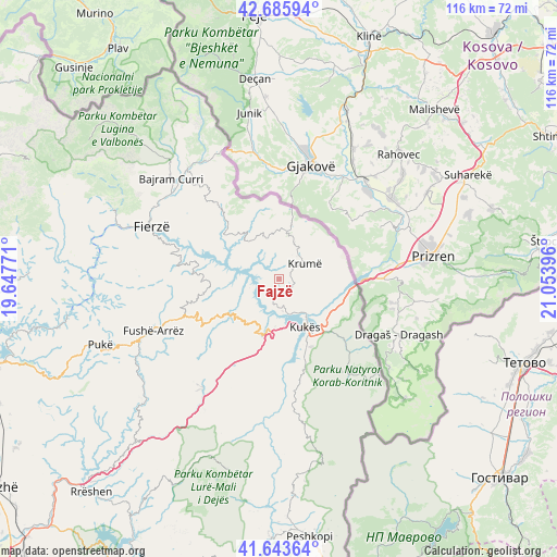
Fajzë GPS coordinates[2]
42° 10' 0.984" North, 20° 21' 2.988" East
| Map corner | latitude | longitude |
|---|---|---|
| Upper-left | 42.68594°, | 19.64771° |
| Center: | 42.16694°, | 20.35083° |
| Lower-right: | 41.64364°, | 21.05396° |
| Map W x H: | 115.9×115.9 km | = 72×72mi |
| max Lat: | 42.45139° ⇑4.2% North |
| Fajzë: | 42.16694° |
| min Lat: | ⇓95.8% South 39.65889° |
| min Long | Fajzë | max Long |
| 19.40556° | 20.35083° | 20.99° |
| W 79.2%⇐ | ⇒20.8% E |
Elevation
Elevation of Fajzë is 428 m = 1404 ft, and this is 53.4 m = 175 ft above average elevation for this country.
| Max E: |
1352 m = 4436 ft | 38.3% |
| Fajzë | 428 m 1404 ft | |
| Avg. | 374.6 m = 1229 ft | |
Min E: |
-2 m = -7 ft | 61.7% |
See also: Albania elevation on elevation.city.
Geographical zone
Fajzë is located in North temperate zone (between Tropic of Cancer and the Arctic Circle). Distance of this Northern Tropic circle is 2082.6 km =1294.1 mi to South.| Distance of | km | miles | from Fajzë |
|---|---|---|---|
| North Pole | 5318.5 | 3304.8 | to North |
| Arctic Circle | 2712.6 | 1685.5 | to North |
| Tropic Cancer | 2082.6 | 1294.1 | to South |
| Equator | 4688.5 | 2913.3 | to South |


Nearby cities:
15 places around Fajzë: (largest is in red/bold)
• Arrën
28.7 km =17.8 mi,  190°
190°
• Bicaj
19.8 km =12.3 mi,  165°
165°
• Blerim
13.1 km =8.1 mi,  266°
266°
• Bytyç
20 km =12.4 mi,  322°
322°
• Gjinaj
8.9 km =5.5 mi,  127°
127°
• Golaj
9.3 km =5.8 mi,  15°
15°
• Kolsh
9.9 km =6.2 mi,  184°
184°
• Krumë
6.1 km =3.8 mi,  57°
57°
• Kukës
11.6 km =7.2 mi,  149°
149°
• Llugaj
27.8 km =17.3 mi,  314°
314°
• Qafëmal
23 km =14.3 mi,  249°
249°
• Shtiqën
15.6 km =9.7 mi, 153°
• Shënmëri
11.6 km =7.2 mi,  233°
233°
• Surroj
19.4 km =12.1 mi, 181°
• Zapod
21.1 km =13.1 mi, 127°
Sources, notices
• [Note1] Compared only with cities in Albania existing in our database
• [Src1] Map data: © OpenStreetMap contributors (CC-BY-SA)
• [Src2] Other city data from geonames.org with taken over terms of usage.
• [Src3] Geographical zone / Annual Mean Temperature by Robert A. Rohde @ Wikipedia
