Qafëmal geodata
Qafëmal (Shkodër) is a seat of a third-order administrative division; located in Albania in Europe/Tirane (GMT+2) time zone. In our database, there are 71 cities with bigger population. Compared to other cities in Albania, 93.8% of cities are located further ↓South; 60.6% of cities are located further ←West and 80.6% of cities have lower elevation than Qafëmal. Note1


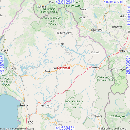
Qafëmal GPS coordinates[2]
42° 5' 35.988" North, 20° 5' 26.016" East
| Map corner | latitude | longitude |
|---|---|---|
| Upper-left | 42.61294°, | 19.38744° |
| Center: | 42.09333°, | 20.09056° |
| Lower-right: | 41.56943°, | 20.79369° |
| Map W x H: | 116×116 km | = 72.1×72.1mi |
| max Lat: | 42.45139° ⇑6.2% North |
| Qafëmal: | 42.09333° |
| min Lat: | ⇓93.8% South 39.65889° |
| min Long | Qafëmal | max Long |
| 19.40556° | 20.09056° | 20.99° |
| W 60.6%⇐ | ⇒39.4% E |
Elevation
Elevation of Qafëmal is 754 m = 2474 ft, and this is 379.4 m = 1245 ft above average elevation for this country.
| Max E: |
1352 m = 4436 ft | 19.4% |
| Qafëmal | 754 m 2474 ft | |
| Avg. | 374.6 m = 1229 ft | |
Min E: |
-2 m = -7 ft | 80.6% |
See also: Albania elevation on elevation.city.
Geographical zone
Qafëmal is located in North temperate zone (between Tropic of Cancer and the Arctic Circle). Distance of this Northern Tropic circle is 2074.4 km =1289 mi to South.| Distance of | km | miles | from Qafëmal |
|---|---|---|---|
| North Pole | 5326.7 | 3309.9 | to North |
| Arctic Circle | 2720.8 | 1690.6 | to North |
| Tropic Cancer | 2074.4 | 1289 | to South |
| Equator | 4680.3 | 2908.2 | to South |


Nearby cities:
15 places around Qafëmal: (largest is in red/bold)
• Blerim
11.2 km =7 mi,  48°
48°
• Bushat
16 km =9.9 mi,  280°
280°
• Fajzë
23 km =14.3 mi,  69°
69°
• Fierzë
19.6 km =12.2 mi,  341°
341°
• Fushë-Arrëz
7 km =4.3 mi,  240°
240°
• Gjegjan
18.5 km =11.5 mi,  200°
200°
• Iballë
12.7 km =7.9 mi,  325°
325°
• Kolsh
20.8 km =12.9 mi,  94°
94°
• Pukë
16.7 km =10.4 mi,  250°
250°
• Qelëz
16.1 km =10 mi,  268°
268°
• Qerret
21.4 km =13.3 mi,  257°
257°
• Rrapë
11.3 km =7 mi, 241°
• Shëngjin
20.3 km =12.6 mi,  156°
156°
• Shënmëri
12.3 km =7.6 mi,  84°
84°
• Surroj
23.8 km =14.8 mi,  118°
118°
Sources, notices
• [Note1] Compared only with cities in Albania existing in our database
• [Src1] Map data: © OpenStreetMap contributors (CC-BY-SA)
• [Src2] Other city data from geonames.org with taken over terms of usage.
• [Src3] Geographical zone / Annual Mean Temperature by Robert A. Rohde @ Wikipedia
