Çarshovë geodata
Çarshovë (Gjirokastër) is a seat of a third-order administrative division; located in Albania in Europe/Tirane (GMT+2) time zone. In our database, there are 71 cities with bigger population. Compared to other cities in Albania, 94.1% of cities are located further ↑North; 90.4% of cities are located further ←West and 55.2% of cities have lower elevation than Çarshovë. Note1


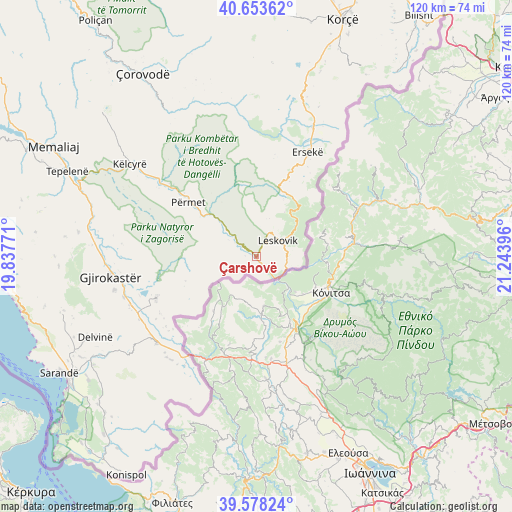
Çarshovë GPS coordinates[2]
40° 7' 5.016" North, 20° 32' 26.988" East
| Map corner | latitude | longitude |
|---|---|---|
| Upper-left | 40.65362°, | 19.83771° |
| Center: | 40.11806°, | 20.54083° |
| Lower-right: | 39.57824°, | 21.24396° |
| Map W x H: | 119.6×119.6 km | = 74.3×74.3mi |
| max Lat: | 42.45139° ⇑94.1% North |
| Çarshovë: | 40.11806° |
| min Lat: | ⇓5.9% South 39.65889° |
| min Long | Çarshovë | max Long |
| 19.40556° | 20.54083° | 20.99° |
| W 90.4%⇐ | ⇒9.6% E |
Elevation
Elevation of Çarshovë is 328 m = 1076 ft, and this is 46.6 m = 153 ft below average elevation for this country.
| Max E: |
1352 m = 4436 ft | 44.8% |
| Avg. | 374.6 m = 1229 ft | |
| Çarshovë | 328 m = 1076 ft | |
Min E: |
-2 m = -7 ft | 55.2% |
See also: Albania elevation on elevation.city.
Geographical zone
Çarshovë is located in North temperate zone (between Tropic of Cancer and the Arctic Circle). Distance of this Northern Tropic circle is 1854.8 km =1152.5 mi to South.| Distance of | km | miles | from Çarshovë |
|---|---|---|---|
| North Pole | 5546.4 | 3446.4 | to North |
| Arctic Circle | 2940.5 | 1827.1 | to North |
| Tropic Cancer | 1854.8 | 1152.5 | to South |
| Equator | 4460.7 | 2771.7 | to South |


Nearby cities:
15 places around Çarshovë: (largest is in red/bold)
• Barmash
18.9 km =11.7 mi,  20°
20°
• Ersekë
27.1 km =16.8 mi,  25°
25°
• Frashër
29.6 km =18.4 mi,  340°
340°
• Gjinkar
14.6 km =9.1 mi,  308°
308°
• Kakavijë
28.1 km =17.5 mi,  213°
213°
• Leskovik
6.1 km =3.8 mi,  52°
52°
• Libohovë
25.5 km =15.8 mi,  247°
247°
• Odrie
31.9 km =19.8 mi,  273°
273°
• Petran
14.5 km =9 mi, 314°
• Piskovë
29 km =18 mi, 308°
• Përmet
20.6 km =12.8 mi, 308°
• Qestorat
29 km =18 mi, 269°
• Saraqinishtë
26.5 km =16.5 mi, 266°
• Skore
14.9 km =9.3 mi, 265°
• Vithkuq
25.8 km =16 mi,  291°
291°
Sources, notices
• [Note1] Compared only with cities in Albania existing in our database
• [Src1] Map data: © OpenStreetMap contributors (CC-BY-SA)
• [Src2] Other city data from geonames.org with taken over terms of usage.
• [Src3] Geographical zone / Annual Mean Temperature by Robert A. Rohde @ Wikipedia
