Goght’ geodata
Goght’ (Kotayk) is a populated place; located in Armenia in Asia/Yerevan (GMT+4) time zone. With population of 1,877 people, there are 171 cities with bigger population in this country. Compared to other cities in Armenia, 62.4% of cities are located further ↑North; 70.7% of cities are located further ←West and 69.1% of cities have lower elevation than Goght’. Note1


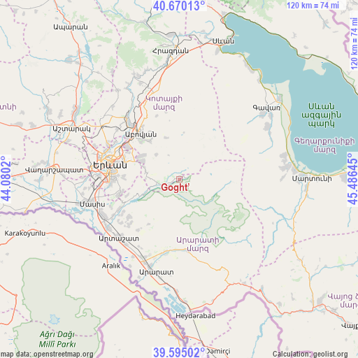
Goght’ GPS coordinates[2]
40° 8' 4.92" North, 44° 46' 59.952" East
| Map corner | latitude | longitude |
|---|---|---|
| Upper-left | 40.67013°, | 44.0802° |
| Center: | 40.1347°, | 44.78332° |
| Lower-right: | 39.59502°, | 45.48645° |
| Map W x H: | 119.5×119.5 km | = 74.3×74.3mi |
| max Lat: | 41.24358° ⇑62.4% North |
| Goght’: | 40.1347° |
| min Lat: | ⇓37.6% South 38.90292° |
| min Long | Goght’ | max Long |
| 43.74722° | 44.78332° | 46.5446° |
| W 70.7%⇐ | ⇒29.3% E |
Elevation
Elevation of Goght’ is 1578 m = 5177 ft, and this is 276.5 m = 907 ft above average elevation for this country.
| Max E: |
2169 m = 7116 ft | 30.9% |
| Goght’ | 1578 m 5177 ft | |
| Avg. | 1301.5 m = 4270 ft | |
Min E: |
440 m = 1444 ft | 69.1% |
See also: Armenia elevation on elevation.city.
Geographical zone
Goght’ is located in North temperate zone (between Tropic of Cancer and the Arctic Circle). Distance of this Northern Tropic circle is 1856.6 km =1153.6 mi to South.| Distance of | km | miles | from Goght’ |
|---|---|---|---|
| North Pole | 5544.5 | 3445.2 | to North |
| Arctic Circle | 2938.6 | 1826 | to North |
| Tropic Cancer | 1856.6 | 1153.6 | to South |
| Equator | 4462.6 | 2772.9 | to South |


Nearby cities:
15 places around Goght’: (largest is in red/bold)
• Abovyan
20 km =12.4 mi,  320°
320°
• Akunk’
16.8 km =10.4 mi,  330°
330°
• Aramus
16.5 km =10.3 mi, 321°
• Balahovit
19.7 km =12.2 mi,  311°
311°
• Bardzrashen
18.2 km =11.3 mi,  252°
252°
• Dvin
21.2 km =13.2 mi,  233°
233°
• Dzoraghbyur
14.3 km =8.9 mi,  302°
302°
• Garrni
4.5 km =2.8 mi, 247°
• Getazat
21.5 km =13.4 mi,  240°
240°
• Kotayk’
18.9 km =11.7 mi, 327°
• Mayakovski
18 km =11.2 mi, 316°
• Nor Gyugh
18.1 km =11.2 mi, 324°
• Ptghni
21.5 km =13.4 mi, 308°
• Verin Dvin
20.5 km =12.7 mi, 233°
• Zarr
14.4 km =8.9 mi,  342°
342°
Sources, notices
• [Note1] Compared only with cities in Armenia existing in our database
• [Src1] Map data: © OpenStreetMap contributors (CC-BY-SA)
• [Src2] Other city data from geonames.org with taken over terms of usage.
• [Src3] Geographical zone / Annual Mean Temperature by Robert A. Rohde @ Wikipedia
