Mayakovski geodata
Mayakovski (Kotayk) is a populated place; located in Armenia in Asia/Yerevan (GMT+4) time zone. With population of 1,727 people, there are 192 cities with bigger population in this country. Compared to other cities in Armenia, 54.1% of cities are located further ↓South; 60.5% of cities are located further ←West and 57% of cities have lower elevation than Mayakovski. Note1


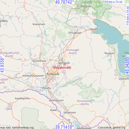
Mayakovski GPS coordinates[2]
40° 15' 10.548" North, 44° 38' 20.112" East
| Map corner | latitude | longitude |
|---|---|---|
| Upper-left | 40.78742°, | 43.9358° |
| Center: | 40.25293°, | 44.63892° |
| Lower-right: | 39.71418°, | 45.34205° |
| Map W x H: | 119.3×119.3 km | = 74.1×74.1mi |
| max Lat: | 41.24358° ⇑45.9% North |
| Mayakovski: | 40.25293° |
| min Lat: | ⇓54.1% South 38.90292° |
| min Long | Mayakovski | max Long |
| 43.74722° | 44.63892° | 46.5446° |
| W 60.5%⇐ | ⇒39.5% E |
Elevation
Elevation of Mayakovski is 1418 m = 4652 ft, and this is 116.5 m = 382 ft above average elevation for this country.
| Max E: |
2169 m = 7116 ft | 43% |
| Mayakovski | 1418 m 4652 ft | |
| Avg. | 1301.5 m = 4270 ft | |
Min E: |
440 m = 1444 ft | 57% |
See also: Armenia elevation on elevation.city.
Geographical zone
Mayakovski is located in North temperate zone (between Tropic of Cancer and the Arctic Circle). Distance of this Northern Tropic circle is 1869.8 km =1161.8 mi to South.| Distance of | km | miles | from Mayakovski |
|---|---|---|---|
| North Pole | 5531.4 | 3437.1 | to North |
| Arctic Circle | 2925.5 | 1817.8 | to North |
| Tropic Cancer | 1869.8 | 1161.8 | to South |
| Equator | 4475.7 | 2781.1 | to South |


Nearby cities:
15 places around Mayakovski: (largest is in red/bold)
• Abovyan
2.4 km =1.5 mi,  348°
348°
• Akunk’
4.3 km =2.7 mi,  69°
69°
• Aramus
2.1 km =1.3 mi,  96°
96°
• Arzni
6 km =3.7 mi,  325°
325°
• Balahovit
2.6 km =1.6 mi,  266°
266°
• Byureghavan
7.8 km =4.8 mi, 330°
• Dzoraghbyur
5.4 km =3.4 mi,  177°
177°
• Kaputan
9.6 km =6 mi,  32°
32°
• Kotayk’
3.5 km =2.2 mi,  37°
37°
• K’anak’erravan
8.8 km =5.5 mi, 266°
• Mrgashen
8.8 km =5.5 mi,  294°
294°
• Nor Geghi
9 km =5.6 mi, 328°
• Nor Gyugh
2.2 km =1.4 mi,  47°
47°
• Ptghni
4.5 km =2.8 mi, 273°
• Zarr
8 km =5 mi,  85°
85°
Sources, notices
• [Note1] Compared only with cities in Armenia existing in our database
• [Src1] Map data: © OpenStreetMap contributors (CC-BY-SA)
• [Src2] Other city data from geonames.org with taken over terms of usage.
• [Src3] Geographical zone / Annual Mean Temperature by Robert A. Rohde @ Wikipedia
