Garrni geodata
Garrni (Kotayk) is a populated place; located in Armenia in Asia/Yerevan (GMT+4) time zone. With population of 6,827 people, there are 33 cities with bigger population in this country. Compared to other cities in Armenia, 65.6% of cities are located further ↑North; 69.1% of cities are located further ←West and 56.7% of cities have lower elevation than Garrni. Note1


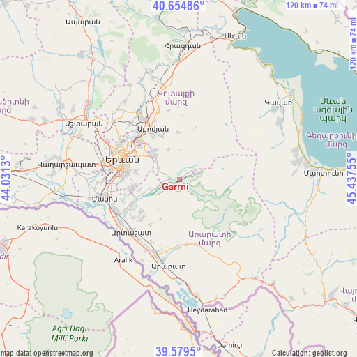
Garrni GPS coordinates[2]
40° 7' 9.516" North, 44° 44' 3.912" East
| Map corner | latitude | longitude |
|---|---|---|
| Upper-left | 40.65486°, | 44.0313° |
| Center: | 40.11931°, | 44.73442° |
| Lower-right: | 39.5795°, | 45.43755° |
| Map W x H: | 119.6×119.6 km | = 74.3×74.3mi |
| max Lat: | 41.24358° ⇑65.6% North |
| Garrni: | 40.11931° |
| min Lat: | ⇓34.4% South 38.90292° |
| min Long | Garrni | max Long |
| 43.74722° | 44.73442° | 46.5446° |
| W 69.1%⇐ | ⇒30.9% E |
Elevation
Elevation of Garrni is 1413 m = 4636 ft, and this is 111.5 m = 366 ft above average elevation for this country.
| Max E: |
2169 m = 7116 ft | 43.3% |
| Garrni | 1413 m 4636 ft | |
| Avg. | 1301.5 m = 4270 ft | |
Min E: |
440 m = 1444 ft | 56.7% |
See also: Armenia elevation on elevation.city.
Geographical zone
Garrni is located in North temperate zone (between Tropic of Cancer and the Arctic Circle). Distance of this Northern Tropic circle is 1854.9 km =1152.6 mi to South.| Distance of | km | miles | from Garrni |
|---|---|---|---|
| North Pole | 5546.2 | 3446.2 | to North |
| Arctic Circle | 2940.3 | 1827 | to North |
| Tropic Cancer | 1854.9 | 1152.6 | to South |
| Equator | 4460.8 | 2771.8 | to South |


Nearby cities:
15 places around Garrni: (largest is in red/bold)
• Abovyan
17.7 km =11 mi,  243°
243°
• Akunk’
16.9 km =10.5 mi,  345°
345°
• Aramus
15.8 km =9.8 mi,  337°
337°
• Balahovit
18.2 km =11.3 mi,  323°
323°
• Bardzrashen
13.7 km =8.5 mi,  253°
253°
• Dvin
16.9 km =10.5 mi,  229°
229°
• Dzoraghbyur
12.3 km =7.6 mi, 320°
• Getazat
17.1 km =10.6 mi, 238°
• Goght’
4.5 km =2.8 mi,  67°
67°
• Mayakovski
16.9 km =10.5 mi,  331°
331°
• Mrganush
18.1 km =11.2 mi, 236°
• Nor Gyugh
17.6 km =10.9 mi, 338°
• Norashen
17.8 km =11.1 mi,  222°
222°
• Verin Dvin
16.2 km =10.1 mi, 229°
• Zarr
15.5 km =9.6 mi,  359°
359°
Sources, notices
• [Note1] Compared only with cities in Armenia existing in our database
• [Src1] Map data: © OpenStreetMap contributors (CC-BY-SA)
• [Src2] Other city data from geonames.org with taken over terms of usage.
• [Src3] Geographical zone / Annual Mean Temperature by Robert A. Rohde @ Wikipedia
