Villa Lugano geodata
Villa Lugano (Buenos Aires F.D.) is a section of populated place; located in Argentina in America/Argentina/Buenos_Aires (GMT-3) time zone. With population of 114,000 people, there are 35 cities with bigger population in this country. Compared to other cities in Argentina, 74.7% of cities are located further ↑North; 84.2% of cities are located further ←West and 94.7% of cities have higher elevation than Villa Lugano. Note1


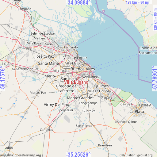
Villa Lugano GPS coordinates[2]
34° 40' 44.652" South, 58° 28' 21.468" West
| Map corner | latitude | longitude |
|---|---|---|
| Upper-left | -34.09884°, | -59.17576° |
| Center: | -34.67907°, | -58.47263° |
| Lower-right: | -35.25526°, | -57.76951° |
| Map W x H: | 128.6×128.6 km | = 79.9×79.9mi |
| max Lat: | -21.94467° ⇑74.7% North |
| Villa Lugano: | -34.67907° |
| min Lat: | ⇓25.3% South -54.81084° |
| min Long | Villa Lugano | max Long |
| -72.88605° | -58.47263° | -53.64581° |
| W 84.2%⇐ | ⇒15.8% E |
Elevation
Elevation of Villa Lugano is 19 m = 62 ft, and this is 330.3 m = 1084 ft below average elevation for this country.
| Max E: |
4040 m = 13255 ft | 94.7% |
| Avg. | 349.3 m = 1146 ft | |
| Villa Lugano | 19 m = 62 ft | |
Min E: |
-2 m = -7 ft | 5.3% |
See also: Villa Lugano elevation on elevation.city.
Geographical zone
Villa Lugano is located in South temperate zone (between Tropic of Capricorn and the Antarctic Circle). Distance of this Southern Tropic circle is 1250 km =776.7 mi to North.| Distance of | km | miles | from Villa Lugano |
|---|---|---|---|
| Equator | 3856 | 2396 | to North |
| Tropic Capricorn | 1250 | 776.7 | to North |
| Antarctic Circle | 3545.2 | 2202.9 | to South |
| South Pole | 6151.1 | 3822.1 | to South |


Nearby cities:
15 places around Villa Lugano: (largest is in red/bold)
• Avellaneda
9.8 km =6.1 mi,  77°
77°
• Balvanera
10.3 km =6.4 mi,  41°
41°
• Barracas
8.8 km =5.5 mi,  68°
68°
• Belgrano
13 km =8.1 mi,  5°
5°
• Boedo
7.2 km =4.5 mi,  45°
45°
• Buenos Aires
11.4 km =7.1 mi, 49°
• Caseros
11.9 km =7.4 mi,  315°
315°
• Colegiales
11.9 km =7.4 mi, 10°
• General San Martín
13 km =8.1 mi,  333°
333°
• Lanús
7.5 km =4.7 mi,  110°
110°
• Lomas de Zamora
10.9 km =6.8 mi,  146°
146°
• Retiro
13.4 km =8.3 mi, 37°
• San Justo
8 km =5 mi,  271°
271°
• Villa Ortúzar
11.1 km =6.9 mi,  2°
2°
• Villa Santa Rita
7.6 km =4.7 mi,  354°
354°
Sources, notices
• [Note1] Compared only with cities in Argentina existing in our database
• [Src1] Map data: © OpenStreetMap contributors (CC-BY-SA)
• [Src2] Other city data from geonames.org with taken over terms of usage.
• [Src3] Geographical zone / Annual Mean Temperature by Robert A. Rohde @ Wikipedia
