Belgrano geodata
Belgrano (Buenos Aires F.D.) is a section of populated place; located in Argentina in America/Argentina/Buenos_Aires (GMT-3) time zone. With population of 138,942 people, there are 33 cities with bigger population in this country. Compared to other cities in Argentina, 72.4% of cities are located further ↑North; 84.5% of cities are located further ←West and 94.9% of cities have higher elevation than Belgrano. Note1


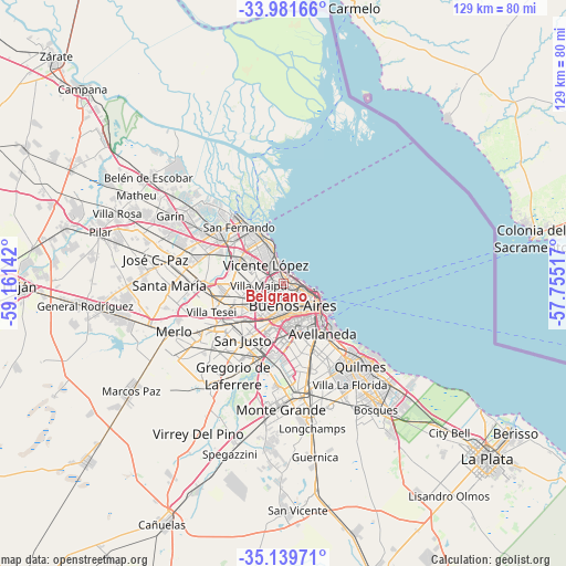
Belgrano GPS coordinates[2]
34° 33' 45.72" South, 58° 27' 29.844" West
| Map corner | latitude | longitude |
|---|---|---|
| Upper-left | -33.98166°, | -59.16142° |
| Center: | -34.5627°, | -58.45829° |
| Lower-right: | -35.13971°, | -57.75517° |
| Map W x H: | 128.8×128.8 km | = 80×80mi |
| max Lat: | -21.94467° ⇑72.4% North |
| Belgrano: | -34.5627° |
| min Lat: | ⇓27.6% South -54.81084° |
| min Long | Belgrano | max Long |
| -72.88605° | -58.45829° | -53.64581° |
| W 84.5%⇐ | ⇒15.5% E |
Elevation
Elevation of Belgrano is 18 m = 59 ft, and this is 331.3 m = 1087 ft below average elevation for this country.
| Max E: |
4040 m = 13255 ft | 94.9% |
| Avg. | 349.3 m = 1146 ft | |
| Belgrano | 18 m = 59 ft | |
Min E: |
-2 m = -7 ft | 5.1% |
See also: Belgrano elevation on elevation.city.
Geographical zone
Belgrano is located in South temperate zone (between Tropic of Capricorn and the Antarctic Circle). Distance of this Southern Tropic circle is 1237.1 km =768.7 mi to North.| Distance of | km | miles | from Belgrano |
|---|---|---|---|
| Equator | 3843 | 2387.9 | to North |
| Tropic Capricorn | 1237.1 | 768.7 | to North |
| Antarctic Circle | 3558.2 | 2211 | to South |
| South Pole | 6164 | 3830.1 | to South |


Nearby cities:
15 places around Belgrano: (largest is in red/bold)
• Avellaneda
13.7 km =8.5 mi,  142°
142°
• Balvanera
7.7 km =4.8 mi,  133°
133°
• Barracas
11.9 km =7.4 mi, 144°
• Boedo
8.7 km =5.4 mi,  154°
154°
• Buenos Aires
9.3 km =5.8 mi, 127°
• Caseros
10.7 km =6.6 mi,  244°
244°
• Colegiales
1.5 km =0.9 mi, 145°
• General San Martín
7.1 km =4.4 mi,  259°
259°
• Olivos
6.7 km =4.2 mi,  336°
336°
• Retiro
7.2 km =4.5 mi,  108°
108°
• San Isidro
11.9 km =7.4 mi,  327°
327°
• San Justo
15.7 km =9.8 mi,  216°
216°
• Villa Lugano
13 km =8.1 mi,  185°
185°
• Villa Ortúzar
2.1 km =1.3 mi,  205°
205°
• Villa Santa Rita
5.7 km =3.5 mi,  201°
201°
Sources, notices
• [Note1] Compared only with cities in Argentina existing in our database
• [Src1] Map data: © OpenStreetMap contributors (CC-BY-SA)
• [Src2] Other city data from geonames.org with taken over terms of usage.
• [Src3] Geographical zone / Annual Mean Temperature by Robert A. Rohde @ Wikipedia
