Avellaneda geodata
Avellaneda (Buenos Aires) is a seat of a second-order administrative division; located in Argentina in America/Argentina/Buenos_Aires (GMT-3) time zone. In our database, there are 785 cities with bigger population. Compared to other cities in Argentina, 74.4% of cities are located further ↑North; 86.2% of cities are located further ←West and 97.1% of cities have higher elevation than Avellaneda. Note1


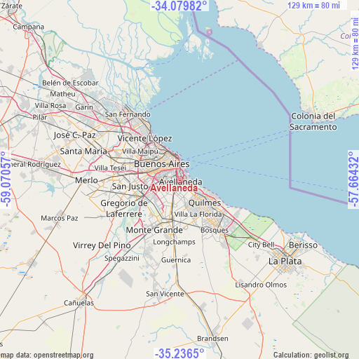
Avellaneda GPS coordinates[2]
34° 39' 36.648" South, 58° 22' 2.784" West
| Map corner | latitude | longitude |
|---|---|---|
| Upper-left | -34.07982°, | -59.07057° |
| Center: | -34.66018°, | -58.36744° |
| Lower-right: | -35.2365°, | -57.66432° |
| Map W x H: | 128.6×128.6 km | = 79.9×79.9mi |
| max Lat: | -21.94467° ⇑74.4% North |
| Avellaneda: | -34.66018° |
| min Lat: | ⇓25.6% South -54.81084° |
| min Long | Avellaneda | max Long |
| -72.88605° | -58.36744° | -53.64581° |
| W 86.2%⇐ | ⇒13.8% E |
Elevation
Elevation of Avellaneda is 13 m = 43 ft, and this is 336.3 m = 1103 ft below average elevation for this country.
| Max E: |
4040 m = 13255 ft | 97.1% |
| Avg. | 349.3 m = 1146 ft | |
| Avellaneda | 13 m = 43 ft | |
Min E: |
-2 m = -7 ft | 2.9% |
See also: Argentina elevation on elevation.city.
Geographical zone
Avellaneda is located in South temperate zone (between Tropic of Capricorn and the Antarctic Circle). Distance of this Southern Tropic circle is 1247.9 km =775.4 mi to North.| Distance of | km | miles | from Avellaneda |
|---|---|---|---|
| Equator | 3853.9 | 2394.7 | to North |
| Tropic Capricorn | 1247.9 | 775.4 | to North |
| Antarctic Circle | 3547.3 | 2204.2 | to South |
| South Pole | 6153.2 | 3823.4 | to South |


Nearby cities:
15 places around Avellaneda: (largest is in red/bold)
• Adrogué
15.7 km =9.8 mi,  185°
185°
• Balvanera
6.2 km =3.9 mi,  333°
333°
• Barracas
1.9 km =1.2 mi,  308°
308°
• Belgrano
13.7 km =8.5 mi,  322°
322°
• Boedo
5.4 km =3.4 mi,  303°
303°
• Buenos Aires
5.3 km =3.3 mi,  350°
350°
• Colegiales
12.2 km =7.6 mi, 322°
• Lanús
5.4 km =3.4 mi,  208°
208°
• Lomas de Zamora
11.7 km =7.3 mi,  197°
197°
• Quilmes
12.2 km =7.6 mi,  128°
128°
• Retiro
8.7 km =5.4 mi, 350°
• San Justo
17.8 km =11.1 mi,  264°
264°
• Villa Lugano
9.8 km =6.1 mi, 257°
• Villa Ortúzar
12.9 km =8 mi, 314°
• Villa Santa Rita
11.7 km =7.3 mi, 297°
Sources, notices
• [Note1] Compared only with cities in Argentina existing in our database
• [Src1] Map data: © OpenStreetMap contributors (CC-BY-SA)
• [Src2] Other city data from geonames.org with taken over terms of usage.
• [Src3] Geographical zone / Annual Mean Temperature by Robert A. Rohde @ Wikipedia
