Luján geodata
Luján (Buenos Aires) is a seat of a second-order administrative division; located in Argentina in America/Argentina/Buenos_Aires (GMT-3) time zone. With population of 81,749 people, there are 52 cities with bigger population in this country. Compared to other cities in Argentina, 72.5% of cities are located further ↑North; 75.1% of cities are located further ←West and 91% of cities have higher elevation than Luján. Note1


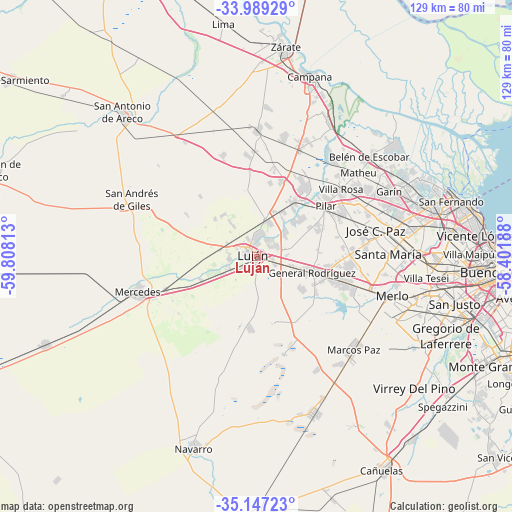
Luján GPS coordinates[2]
34° 34' 13.008" South, 59° 6' 18" West
| Map corner | latitude | longitude |
|---|---|---|
| Upper-left | -33.98929°, | -59.80813° |
| Center: | -34.57028°, | -59.105° |
| Lower-right: | -35.14723°, | -58.40188° |
| Map W x H: | 128.8×128.8 km | = 80×80mi |
| max Lat: | -21.94467° ⇑72.5% North |
| Luján: | -34.57028° |
| min Lat: | ⇓27.5% South -54.81084° |
| min Long | Luján | max Long |
| -72.88605° | -59.105° | -53.64581° |
| W 75.1%⇐ | ⇒24.9% E |
Elevation
Elevation of Luján is 27 m = 89 ft, and this is 322.3 m = 1057 ft below average elevation for this country.
| Max E: |
4040 m = 13255 ft | 91% |
| Avg. | 349.3 m = 1146 ft | |
| Luján | 27 m = 89 ft | |
Min E: |
-2 m = -7 ft | 9% |
See also: Luján elevation on elevation.city.
Geographical zone
Luján is located in South temperate zone (between Tropic of Capricorn and the Antarctic Circle). Distance of this Southern Tropic circle is 1237.9 km =769.2 mi to North.| Distance of | km | miles | from Luján |
|---|---|---|---|
| Equator | 3843.9 | 2388.5 | to North |
| Tropic Capricorn | 1237.9 | 769.2 | to North |
| Antarctic Circle | 3557.3 | 2210.4 | to South |
| South Pole | 6163.2 | 3829.6 | to South |


Nearby cities:
15 places around Luján: (largest is in red/bold)
• Belén de Escobar
37.8 km =23.5 mi,  49°
49°
• Capilla del Señor
30.9 km =19.2 mi,  0°
0°
• General Rodríguez
14.6 km =9.1 mi,  106°
106°
• Ingeniero Pablo Nogués
37.9 km =23.5 mi,  74°
74°
• José C. Paz
31.5 km =19.6 mi,  78°
78°
• Los Polvorines
37.3 km =23.2 mi, 78°
• Marcos Paz
34 km =21.1 mi,  133°
133°
• Mercedes
31.1 km =19.3 mi,  253°
253°
• Merlo
36 km =22.4 mi, 107°
• Muñiz
36.4 km =22.6 mi,  87°
87°
• Pilar
21.4 km =13.3 mi, 54°
• San Andrés de Giles
34 km =21.1 mi,  293°
293°
• San Miguel
36.1 km =22.4 mi, 85°
• Tortuguitas
33.9 km =21.1 mi, 71°
• Villa de Mayo
39.4 km =24.5 mi, 80°
Sources, notices
• [Note1] Compared only with cities in Argentina existing in our database
• [Src1] Map data: © OpenStreetMap contributors (CC-BY-SA)
• [Src2] Other city data from geonames.org with taken over terms of usage.
• [Src3] Geographical zone / Annual Mean Temperature by Robert A. Rohde @ Wikipedia
