General Rodríguez geodata
General Rodríguez (Buenos Aires) is a seat of a second-order administrative division; located in Argentina in America/Argentina/Buenos_Aires (GMT-3) time zone. In our database, there are 785 cities with bigger population. Compared to other cities in Argentina, 73.3% of cities are located further ↑North; 77% of cities are located further ←West and 87.4% of cities have higher elevation than General Rodríguez. Note1


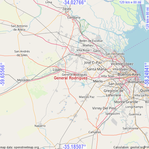
General Rodríguez GPS coordinates[2]
34° 36' 30.168" South, 58° 57' 9.108" West
| Map corner | latitude | longitude |
|---|---|---|
| Upper-left | -34.02766°, | -59.65566° |
| Center: | -34.60838°, | -58.95253° |
| Lower-right: | -35.18507°, | -58.24941° |
| Map W x H: | 128.7×128.7 km | = 80×80mi |
| max Lat: | -21.94467° ⇑73.3% North |
| General Rodríguez: | -34.60838° |
| min Lat: | ⇓26.7% South -54.81084° |
| min Long | General Rodríg | max Long |
| -72.88605° | -58.95253° | -53.64581° |
| W 77%⇐ | ⇒23% E |
Elevation
Elevation of General Rodríguez is 34 m = 112 ft, and this is 315.3 m = 1034 ft below average elevation for this country.
| Max E: |
4040 m = 13255 ft | 87.4% |
| Avg. | 349.3 m = 1146 ft | |
| General Rodríguez | 34 m = 112 ft | |
Min E: |
-2 m = -7 ft | 12.6% |
See also: Argentina elevation on elevation.city.
Geographical zone
General Rodríguez is located in South temperate zone (between Tropic of Capricorn and the Antarctic Circle). Distance of this Southern Tropic circle is 1242.2 km =771.9 mi to North.| Distance of | km | miles | from General Rodríguez |
|---|---|---|---|
| Equator | 3848.1 | 2391.1 | to North |
| Tropic Capricorn | 1242.2 | 771.9 | to North |
| Antarctic Circle | 3553.1 | 2207.8 | to South |
| South Pole | 6159 | 3827 | to South |


Nearby cities:
15 places around General Rodríguez: (largest is in red/bold)
• Hurlingham
29.7 km =18.5 mi,  86°
86°
• Ingeniero Pablo Nogués
26.8 km =16.7 mi,  57°
57°
• Ituzaingó
27 km =16.8 mi,  101°
101°
• José C. Paz
19.8 km =12.3 mi, 58°
• Los Polvorines
25.4 km =15.8 mi, 62°
• Luján
14.6 km =9.1 mi,  286°
286°
• Marcos Paz
22 km =13.7 mi,  151°
151°
• Merlo
21.4 km =13.3 mi,  107°
107°
• Morón
30.8 km =19.1 mi, 98°
• Muñiz
23.2 km =14.4 mi,  75°
75°
• Pilar
17 km =10.6 mi,  11°
11°
• Pontevedra
27.8 km =17.3 mi,  123°
123°
• San Miguel
23.2 km =14.4 mi,  71°
71°
• Tortuguitas
23.5 km =14.6 mi,  50°
50°
• Villa de Mayo
27.2 km =16.9 mi, 66°
Sources, notices
• [Note1] Compared only with cities in Argentina existing in our database
• [Src1] Map data: © OpenStreetMap contributors (CC-BY-SA)
• [Src2] Other city data from geonames.org with taken over terms of usage.
• [Src3] Geographical zone / Annual Mean Temperature by Robert A. Rohde @ Wikipedia
