La Verde geodata
La Verde (Chaco) is a populated place; located in Argentina in America/Argentina/Cordoba (GMT-3) time zone. With population of 2,995 people, there are 552 cities with bigger population in this country. Compared to other cities in Argentina, 85.2% of cities are located further ↓South; 73% of cities are located further ←West and 76.5% of cities have higher elevation than La Verde. Note1


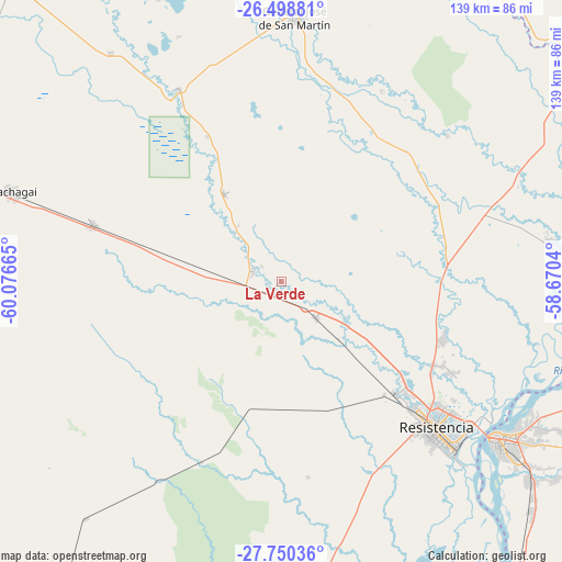
La Verde GPS coordinates[2]
27° 7' 34.824" South, 59° 22' 24.672" West
| Map corner | latitude | longitude |
|---|---|---|
| Upper-left | -26.49881°, | -60.07665° |
| Center: | -27.12634°, | -59.37352° |
| Lower-right: | -27.75036°, | -58.6704° |
| Map W x H: | 139.2×139.2 km | = 86.5×86.5mi |
| max Lat: | -21.94467° ⇑14.8% North |
| La Verde: | -27.12634° |
| min Lat: | ⇓85.2% South -54.81084° |
| min Long | La Verde | max Long |
| -72.88605° | -59.37352° | -53.64581° |
| W 73%⇐ | ⇒27% E |
Elevation
Elevation of La Verde is 67 m = 220 ft, and this is 282.3 m = 926 ft below average elevation for this country.
| Max E: |
4040 m = 13255 ft | 76.5% |
| Avg. | 349.3 m = 1146 ft | |
| La Verde | 67 m = 220 ft | |
Min E: |
-2 m = -7 ft | 23.5% |
See also: Argentina elevation on elevation.city.
Geographical zone
La Verde is located in South temperate zone (between Tropic of Capricorn and the Antarctic Circle). Distance of this Southern Tropic circle is 410.2 km =254.9 mi to North.| Distance of | km | miles | from La Verde |
|---|---|---|---|
| Equator | 3016.2 | 1874.2 | to North |
| Tropic Capricorn | 410.2 | 254.9 | to North |
| Antarctic Circle | 4385 | 2724.7 | to South |
| South Pole | 6990.9 | 4343.9 | to South |


Nearby cities:
15 places around La Verde: (largest is in red/bold)
• Capitán Solari
40.5 km =25.2 mi,  332°
332°
• Colonia Benítez
48 km =29.8 mi,  118°
118°
• Colonia Elisa
26.1 km =16.2 mi, 326°
• Colonias Unidas
54 km =33.6 mi, 331°
• Coté-Lai
47.2 km =29.3 mi,  208°
208°
• Fontana
47.4 km =29.5 mi,  133°
133°
• La Eduvigis
44.7 km =27.8 mi,  43°
43°
• La Escondida
7.7 km =4.8 mi,  286°
286°
• Lapachito
3.9 km =2.4 mi,  198°
198°
• Makallé
12.4 km =7.7 mi,  136°
136°
• Margarita Belén
42.4 km =26.3 mi,  110°
110°
• Pampa Almirón
53.5 km =33.2 mi,  27°
27°
• Presidencia de la Plaza
48.5 km =30.1 mi, 286°
• Puerto Tirol
39.7 km =24.7 mi, 133°
• Resistencia
53.5 km =33.2 mi, 133°
Sources, notices
• [Note1] Compared only with cities in Argentina existing in our database
• [Src1] Map data: © OpenStreetMap contributors (CC-BY-SA)
• [Src2] Other city data from geonames.org with taken over terms of usage.
• [Src3] Geographical zone / Annual Mean Temperature by Robert A. Rohde @ Wikipedia
