Fontana geodata
Fontana (Chaco) is a populated place; located in Argentina in America/Argentina/Cordoba (GMT-3) time zone. With population of 26,745 people, there are 152 cities with bigger population in this country. Compared to other cities in Argentina, 82.1% of cities are located further ↓South; 76.3% of cities are located further ←West and 82.2% of cities have higher elevation than Fontana. Note1


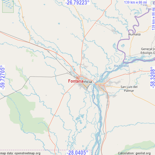
Fontana GPS coordinates[2]
27° 25' 5.268" South, 59° 1' 26.112" West
| Map corner | latitude | longitude |
|---|---|---|
| Upper-left | -26.79223°, | -59.72705° |
| Center: | -27.41813°, | -59.02392° |
| Lower-right: | -28.0405°, | -58.3208° |
| Map W x H: | 138.8×138.8 km | = 86.2×86.2mi |
| max Lat: | -21.94467° ⇑17.9% North |
| Fontana: | -27.41813° |
| min Lat: | ⇓82.1% South -54.81084° |
| min Long | Fontana | max Long |
| -72.88605° | -59.02392° | -53.64581° |
| W 76.3%⇐ | ⇒23.7% E |
Elevation
Elevation of Fontana is 54 m = 177 ft, and this is 295.3 m = 969 ft below average elevation for this country.
| Max E: |
4040 m = 13255 ft | 82.2% |
| Avg. | 349.3 m = 1146 ft | |
| Fontana | 54 m = 177 ft | |
Min E: |
-2 m = -7 ft | 17.8% |
See also: Argentina elevation on elevation.city.
Geographical zone
Fontana is located in South temperate zone (between Tropic of Capricorn and the Antarctic Circle). Distance of this Southern Tropic circle is 442.7 km =275.1 mi to North.| Distance of | km | miles | from Fontana |
|---|---|---|---|
| Equator | 3048.6 | 1894.3 | to North |
| Tropic Capricorn | 442.7 | 275.1 | to North |
| Antarctic Circle | 4352.6 | 2704.6 | to South |
| South Pole | 6958.5 | 4323.8 | to South |


Nearby cities:
15 places around Fontana: (largest is in red/bold)
• Barranqueras
10.9 km =6.8 mi,  130°
130°
• Colonia Benítez
12.4 km =7.7 mi,  38°
38°
• Corrientes
19.5 km =12.1 mi,  106°
106°
• La Leonesa
52.8 km =32.8 mi, 36°
• La Verde
47.4 km =29.5 mi,  313°
313°
• Lapachito
45.9 km =28.5 mi, 308°
• Makallé
35 km =21.7 mi, 312°
• Margarita Belén
18.1 km =11.2 mi,  16°
16°
• Paso de la Patria
46 km =28.6 mi,  75°
75°
• Puerto Tirol
7.7 km =4.8 mi, 311°
• Puerto Vilelas
13.6 km =8.5 mi,  141°
141°
• Resistencia
6.2 km =3.9 mi, 140°
• Riachuelo
33 km =20.5 mi,  123°
123°
• San Cosme
50.8 km =31.6 mi, 84°
• San Luis del Palmar
47.4 km =29.5 mi,  102°
102°
Sources, notices
• [Note1] Compared only with cities in Argentina existing in our database
• [Src1] Map data: © OpenStreetMap contributors (CC-BY-SA)
• [Src2] Other city data from geonames.org with taken over terms of usage.
• [Src3] Geographical zone / Annual Mean Temperature by Robert A. Rohde @ Wikipedia
